Balkan Mosaic

Cultural tour of Balkans - Serbia, Bosnia & Herzegovina, Kosovo, North Macedonia, Albania, Montenegro, Croatia & Slovenia

Discover 16 UNESCO World Heritage Sites in 8 countries on this epic journey through the Balkans region, including explorations of Serbia, Bosnia & Herzegovina, Kosovo, North Macedonia, Albania, Montenegro, Croatia and Slovenia. With multiple settlements dating back to prehistoric times, the Balkans has seen the rise and fall of many empires over the centuries. From the Romans to the Venetians to the Ottomans, each empire has left its touch on the spectacular monuments and diverse cultures found here. Against a backdrop of jagged mountain peaks and dramatic coastlines, we discover pristinely preserved medieval villages, grandiose Roman structures, towering Ottoman mosques and more.

Travel stress-free as we take care of all the details with this artfully curated small group tour allowing you to experience the best of the region. Our Balkan Mosaic journey has been split into two segments, with a choice of taking only the first or second part, or the complete tour! Options to take this journey as  a private group, or customize the itinerary to your exact requirements are also available. Contact us for further details.

UNESCO World Heritage Sites covered in this tour
Segment One
1. Berat 2. Monastery Studenica
3. Cathedral of St James in Šibenik 4. Monastery Sopoćani
5. Episcopal Complex of the Euphrasian Basilica in the Historic Centre of Poreč 6. Medieval Monuments in Kosovo
7. Historic City of Trogir 8. Ohrid
9. Historical Complex of Split with the Palace of Diocletian 10. Old Bridge Area of the Old City of Mostar
11. Kotor    
Segment Two
12. Old City of Dubrovnik 13. Mehmed Paša Sokolović Bridge of Višegrad
14. Plitvice Lakes National Park 15. Venetian Works of Defence between the 16th and 17th Centuries: Stato da Terra – Western Stato da Mar
16. The works of Jože Plečnik in Ljubljana – Human Centred Urban Design    
Tour Information
Duration : 15/26 days
Minimum : 02 persons
Maximum : 12 persons
Price (From) : US$ 5440
International air not included
Segment One: Serbia, Bosnia & Herzegovina, Kosovo, North Macedonia, Albania & Montenegro
Day 01: Arrive Belgrade (SERBIA)
Day 02: Belgrade
(B, D)
Day 03: Belgrade/Visegrad (BOSNIA & HERZEGOVINA)/Zlatibor (SERBIA) (Drive)
(B, D)
Day 04: Zlatibor/Novi Pazar (Drive)
(B, D)
Day 05: Novi Pazar/Pec (KOSOVO) (Drive)
(B, D)
Day 06: Pec/Pristina/Skopje (NORTH MACEDONIA)
(B, D)
Day 07: Skopje/Ohrid (Drive)
(B, D)
Day 08: Ohrid
(B, D)
Day 09: Ohrid/Berat (ALBANIA)/Tirana (Drive)
(B, D)
Day 10: Tirana/Durres/Tirana (Drive)
(B, D)
Day 11: Tirana/Kruja/Shkoder/Budva (Drive) (MONTENEGRO)
(B, D)
Day 12: Budva/Cetinje/Kotor/Budva
(B, D)
Day 13: Budva/Trebinje (BOSNIA & HERZEGOVINA)/Medjugorje/Mostar (Drive)
(B, D)
Day 14: Mostar/Sarajevo (Drive)
(B, D)
Day 15: Depart Sarajevo
(B)
Segment Two: Croatia & Slovenia
Day 15: Sarajevo/Durbrovnik (Drive) (CROATIA)
(B)
Day 16: Dubrovnik
(B)
Day 17: Dubrovnik/Split or Trogir (Drive)
(B)
Day 18: Split
(B)
Day 19: Split or Trogir/Opatija (Drive)
(B)
Day 20: Opatija/Pula/Rovinji/Porec (Drive)
(B)
Day 21: Porec
(B)
Day 22: Porec/Postojna/Ljubljana (SLOVENIA) (Drive)
(B)
Day 23: Ljubljana/Bled (Drive)
(B)
Day 24: Bled/Plitvice Lakes (CROATIA) (Drive)
(B)
Day 25: Plitvice Lakes/Zagreb (Drive)
(B)
Day 26: Depart Zagreb
(B)
B=Breakfast, L=Lunch, D=Dinner

Segment One: Serbia, Bosnia & Herzegovina, Kosovo, North Macedonia, Albania & Montenegro

Day 01: Arrive Belgrade (SERBIA)

Welcome to charming Belgrade, one of the oldest continuously inhabited cities in Europe and the capital of Serbia since 1403. Originally home to one of the most important prehistoric cultures of Europe, the Vinča, this region has been ruled by the Romans, the Slavs, the Byzantine Empire and the Bulgarian Empire throughout the centuries. Upon arrival, we are warmly received and transferred to our hotel. Our afternoon is free to explore this romantic city.
Overnight: Hotel Moskva, Belgrade (2 nights)

Day 02: Belgrade

National Museum and monument of prince Mihailo, Belgrade Serbia

Our in-depth journey exploring the Balkans starts with a drive through New Belgrade, which is located on the bank of the River Sava.  After reaching the old town, we stop at the Memorial Complex of Josip Broz Tito, the legendary president of Yugoslavia. On our way to the center of the city, we will see the new Saint Sava Church, which is the third largest Orthodox Church in Europe, the Former Federal Assembly Building of Yugoslavia, the Church of Saint Marko, the Royal Palaces of the Serbian dynasties until WWII, and Terazije Square. In the afternoon, we walk from elegant Republic Square, which is surrounded by the National Theatre and the National Museum. We stroll along Knez Mihajlova Street, the main shopping and meeting place of the city. We then visit the old quarter, walking by the 'Question mark sign' Inn and Princess Ljubica's Residence, as well as the Patriarchy and the Orthodox Cathedral. Next, we explore at Kalemegdan Fortress, a symbol of Belgrade that has been destroyed and rebuilt many times over the course of its 16 centuries. We start in the Upper Fortress area, then explore the Eastern Ward, the Nebojsa Tower, the Baroque Gate of Karl VI, and the remains of the medieval metropolitan palace. In the evening, we enjoy a welcome dinner at the local Bohemian quarters of Skadarlija with Serbian cuisine and music. (B, D)

Day 03: Belgrade/Visegrad (BOSNIA & HERZEGOVINA)/Zlatibor (SERBIA) (Drive)

Today is a treat for rail buffs, photographers and nature lovers. We start with a ride on the Sarganska Osmica, a narrow-gauge heritage steam train, which traverses beautiful landscapes through 20 tunnels and across 10 bridges. Afterwards, we cross the Drina River into the Republika Srpska in Bosnia & Herzegovina to visit the Mehmed Paša Sokolović Bridge of Višegrad*. Built at the end of the 16th century, the bridge has 11 masonry arches and is a representative masterpiece of Sinan, one of the greatest architects and engineers of the classical Ottoman period. We then ascend Mount Zlatibor National Park and visit an open-air museum displaying traditional architecture and handicrafts, as well as world famous hand-knitted clothes. We walk through the village before checking into our hotel.
Overnight: Hotel Staro Selo or Hotel Mecavnik, Zlatibor (1 night) (B, D)

Day 04: Zlatibor/Novi Pazar (Drive)

Gypsy dancer

We visit the Monastery Studenica*, founded in 1190 and best known for its collection of 13th and 14th century Byzantine-style fresco paintings. This UNESCO World Heritage Site includes the churches of the Virgin, Saints Joachim and Anne, and Saint Nicholas. We then head to Novi Pazar and take an evening walking tour of the town. Predominantly Muslim, Novi Pazar’s story began in the 1400s when the Ottoman governor of the region built a fort, mosque, market and baths here.
Overnight: Hotel Emrovic Raj, Novi Pazar (1 night) (B, D)

Day 05: Novi Pazar/Pec (KOSOVO) (Drive)

A short drive brings us to one of the most treasured sacral buildings of the Nemanjić era, the Monastery Sopoćani*, featuring magnificent medieval murals. This UNESCO World Heritage Site was thought to have been built around 1260. After our exploration of the monastery, we continue to Kosovo, Europe’s newest country. The Medieval Monuments in Kosovo* are world renowned for their beauty. These four churches and monasteries were built in the 13th and 14th centuries, and are famous for their distinctive style of wall painting, developed in the Balkans from the 13th to 17th centuries.
Overnight: Hotel Dukagjini, Pec (1 night) (B, D)

Day 06: Pec/Pristina/Skopje (NORTH MACEDONIA)

Traditional pepper relish from the Balkans with sausage

Today, explore Dečani Monastery and the Patriarchate of Peć. Dečani Church boasts some of the richest and most well preserved Romanesque-Gothic sculptures in the region. At the Patriarchate of Peć, we visit the monastery’s oldest church, built in the 13th century. Next, we journey to Kosovo’s capital city of Pristina, with the opportunity to stroll along its streets and enjoy its main square. We visit the 14th century Monastery of Gracanica, which represents the culmination of Serbian buildings that followed the Byzantine tradition.  We then head into North Macedonia, offering a unique mix of Greek, Roman and Ottoman heritage. Our destination is the country’s charming capital of Skopje.
Overnight: Hotel Alexandar II, Skopje (1 night) (B, D)

Day 07: Skopje/Ohrid (Drive)

With the earliest evidence of settlement dating to 4000 BC, Skopje offers a long and fascinating history spanning through Roman times and beyond. In the morning, we walk through the old town “Charshi”, visiting the Stone Bridge built by the Ottomans and the Church of Saint Spas. We then explore the Old Bazaar, largest bazaar in the Balkans and trade centre of Skopje since the 12th century, and Fortress Kale, where the city’s oldest artifacts were found. Our explorations conclude with visits to Mustapha Pasha Mosque, dating from 1492, and the Daut Pasa Baths (only from the outside).  Afterwards, we head to Ohrid.
Overnight: City Hotel, Ohrid (2 nights) (B, D)

Day 08: Ohrid

Church of St. Jovan (St. John the Theologian) at Kaneo and Ohrid Lake at sunset, Ohrid, Macedonia

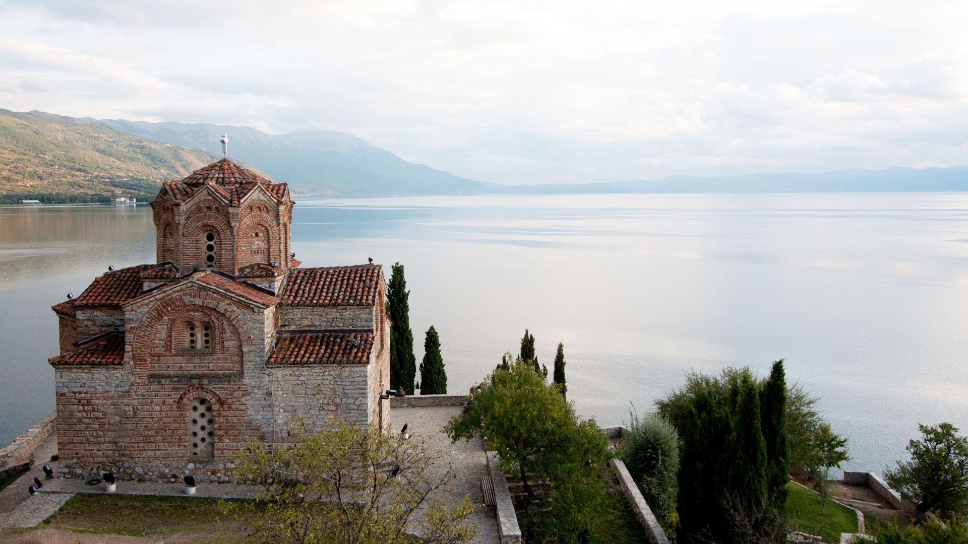
A delightful experience ahead today as we discover Ohrid*, providing a postcard-perfect picture with its setting on the lake of the same name. The old part of Ohrid was known in ancient times as Lychnidos, or the City of Lights. It was here as well where the Cyrillic alphabet was created by brothers Cyril and Methody in the 9th century. Start with a walking tour around the museum-like old town. Ohrid is also known as the City of 365 Churches, and we visit the churches of Saint Kliment, Saint Sophia and Saint Panteleimon. We also explore the Tsar Smuili Fortress, which served as capital of the First Bulgarian Empire during the Middle Ages. Our stroll culminates at the local bazaar. Afternoon is free to explore Ohrid’s picturesque streets and attractions. (B, D)

Day 09: Ohrid/Berat (ALBANIA)/Tirana (Drive)

We drive around Lake Ohrid and enter Albania. Closed to ousiders for much of the 20th century, this country offers a unique mix of majestic mountains, Greek, Roman and Ottoman monuments, and cultural quirks. Today, we visit Berat*. Due to its many buildings scenically stacked on the slopes of a hill, Berat is known as the City of 1001 Windows. Sitting on the hilltop is the city’s crown jewel, Berat Castle.  During our explorations today, we see paintings by Onufri, an outstanding painter from the 16th century, as well as paintings from his son Nikolla. We visit several Byzantine churches in the old town before continueing to Tirana.
Overnight: Hotel Rogner, Tirana (2 nights) (B, D)

Day 10: Tirana/Durres/Tirana (Drive)

Young balkan woman

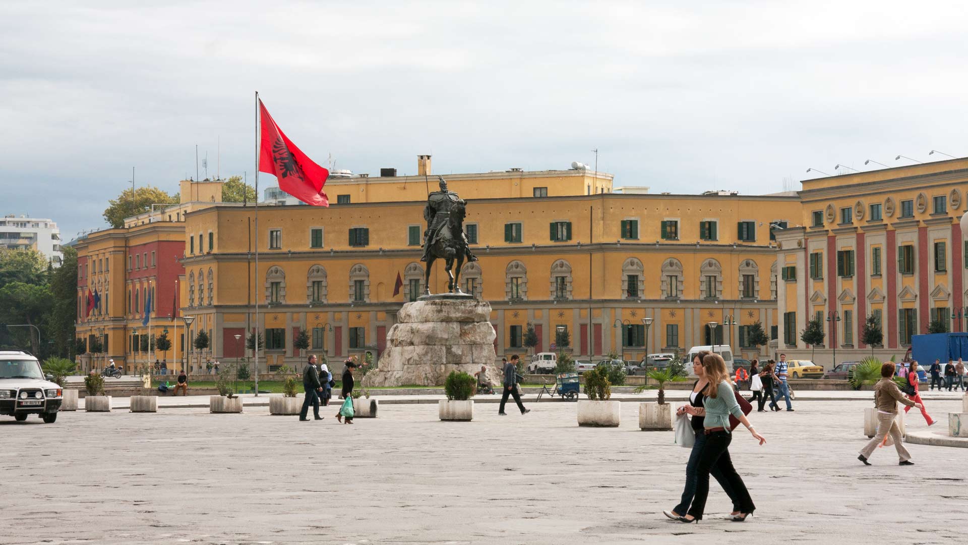
Enjoy a scenic drive to Durres (formerly Durrazzo), Albania’s second largest city and one of its oldest towns, dating back to 7th century BC. For hundeds of years, it was the largest port on the Adriatic. The highlight of our visit here is the Roman amphitheatre, one of the ten most beautiful Roman amphitheatres in the world. Afterwards, we return to Tirana to discover this colourful city. Here, we visit Skanderbeg Square in the centre of the town, the Mosque of Et’hem Bey, dating to 1789, the Clock Tower, dating to 1830, and the Palace of Culture housing the Opera (view from the outside only). Evening is at leisure to further explore Tirana’s cosmopolitan charms. (B, D)

Day 11: Tirana/Kruja/Shkoder/Budva (Drive) (MONTENEGRO)

Experience the scenic town of Kruja, perched high on the face of a hill. In the 15th century, Kruja was the centre of the Albanian resistance in the rebellion against the Ottomans, led by the now legendary Skanderbeg. We explore the museum here that commemorates Albania’s national hero before crossing the border into Montenegro. We spend the night in Budva, one of the oldest settlements on the Adriatic Coast.
Overnight: Hotel Budva or Hotel Kotor, Budva (2 nights) (B, D)

Day 12: Budva/Cetinje/Kotor/Budva

Ship near Kotor in Montenegro

We explore Budva, a well-preserved medieval town offering enchantingly narrow streets lined with shops and taverns.  Afterwards, a scenic drive gets us to Cetinje, capital of Montenegro during the Njegoš era, where we visit the royal palace of King Nikola II, last King of Montenegro. Next, we travel to Kotor*, a town inhabited since Illyrian and Roman times. Our walk through the city takes us back to the Middle Ages, when Kotor was an important artistic and commercial centre. The city walls of Kotor were originally built by the Republic of Venice in the 16th and 17th centuries to protect its trading interests, and it’s a part of the Venetian Works of Defence* World Heritage Site.  We also visit the Cathedral of Saint Tryphon before our return to Budva. (B, D)

Day 13: Budva/Trebinje (BOSNIA & HERZEGOVINA)/Medjugorje/Mostar (Drive)

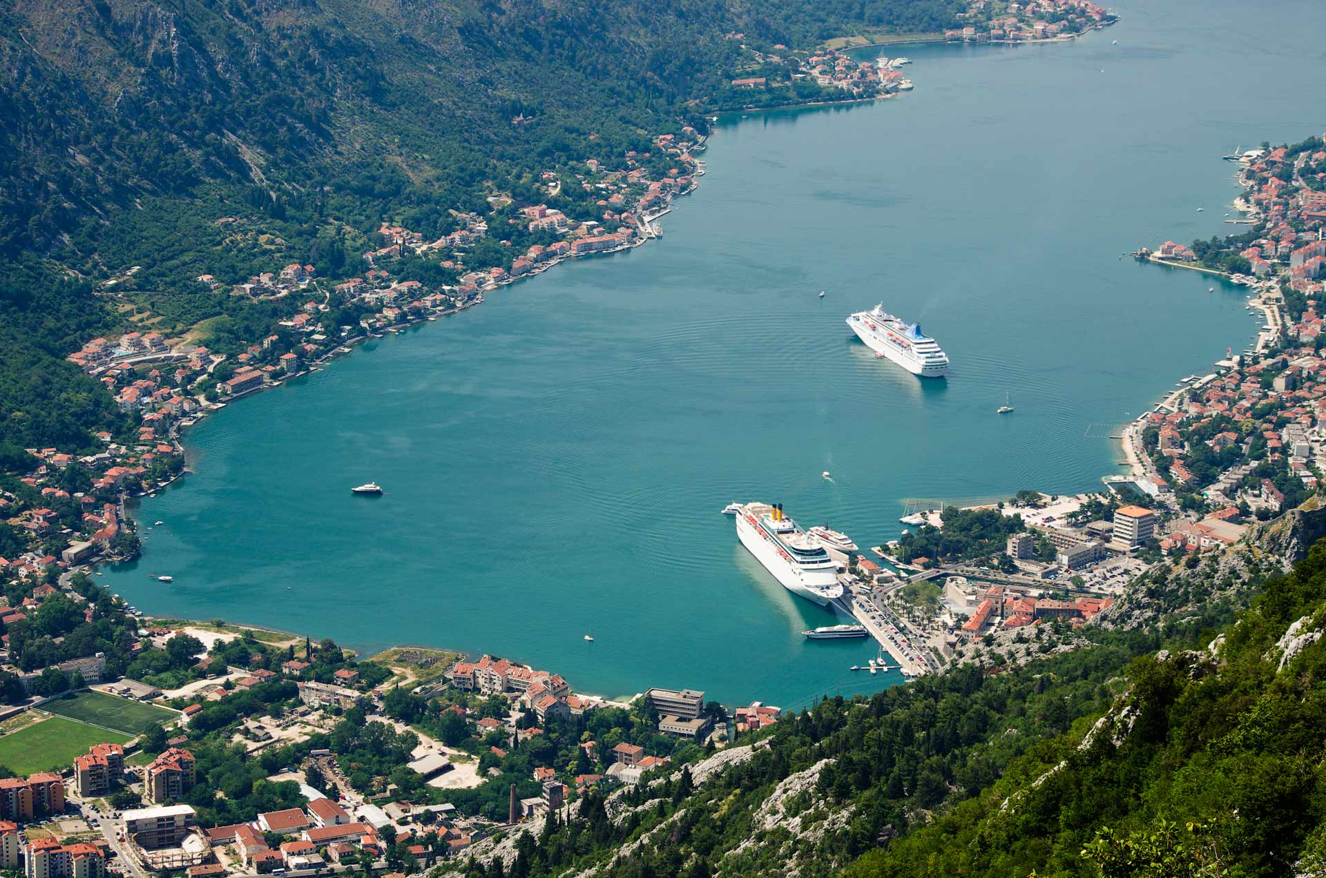
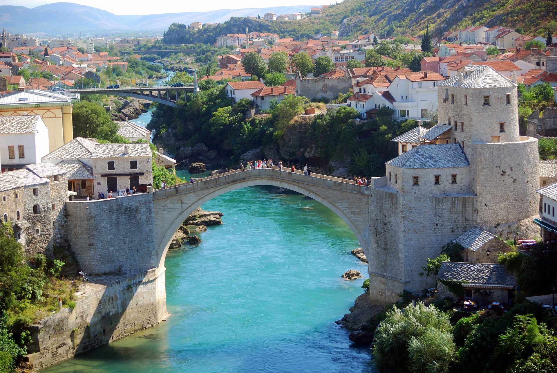
We drive along picturesque Boka Bay before heading inland through beautiful mountain scenery. We soon cross the border into Bosnia & Herzegovina and come to the village of Medjugorje, a major Roman Catholic pilgrimage centre. It is reputed that in 1981, several local children received messages from the Virgin Mary. We then travel to Mostar* to see the famous Ottoman bridge, built in 1557 during the times of Suleiman the Magnificent to unify the communities residing along the Neretva River.
Overnight: Hotel Eden, Mostar (1 night) (B, D)

Day 14: Mostar/Sarajevo (Drive)

The Old Bridge, Mostar, Bosnia-Herzegovina

A lovely journey ahead today as we drive along Neretva River and the Bosnian Mountains to enchanting Sarajevo, said to be a miniature version of Istanbul. Our walking tour of Sarajevo takes us instantly back to the Ottoman days as we visit the beautiful old quarters and authentic Turkish carsija (city centre), with its oriental sweet shops, cafes and traditional Bosnian food. Evening is free to further explore Sarajevo’s multicultural flavours. A walk around the alleys and gulleys of Sarajevo’s Old Town, especially at sunset, is something that one we can ever forget. It will take you to the era of the Arabian Nights, 1001 Nights, Alibaba, Alladin and more.

Overnight: Hotel Europe, Sarajevo (1 night) (B, D)

Day 15: Depart Sarajevo

For more than 400 years, Ottoman mosques, Orthodox churches, Roman-Catholic cathedrals and Jewish synagogues have all called Sarajevo home—in fact, Sarajevo is said to be one of the most multicultural cities in Europe! We will explore the history of this unique place, meet local folks at the bazaar and also visit the site where, on June 28, 1914, Archduke Franz Ferdinand of Austria and his wife Sophie were assassinated, an event that triggered World War I.

Afternoon, we are transferred to the airport for our depature flight or, better still, join us on a private extension tour to the other Balkan states of Croatia & Slovenia. Please see details. (B)

Segment Two: Croatia & Slovenia

Day 15: Sarajevo/Durbrovnik (Drive) (CROATIA)

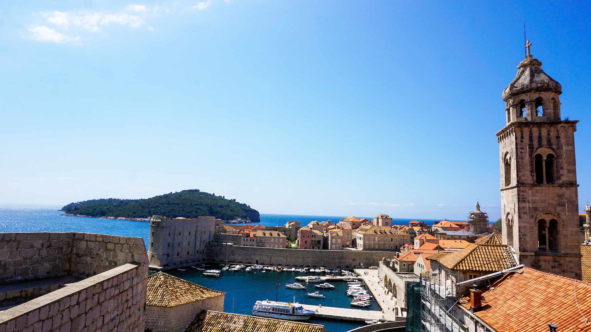
For those taking Segment, we depart Sarajevo in the afternoon and after the morning tour of Sarajevo on a scenic drive through to Dubrovnik, the enchanting and historic resort city on the Adriatic Sea.
Overnight: Hotel Lero, Dubrovnik (2 nights) (B)

Day 16: Dubrovnik

Croatia Dubrovnik Harbor and historical center UNESCO World Heritage Site restored after being damaged by heavy bombardments in the Balkan war

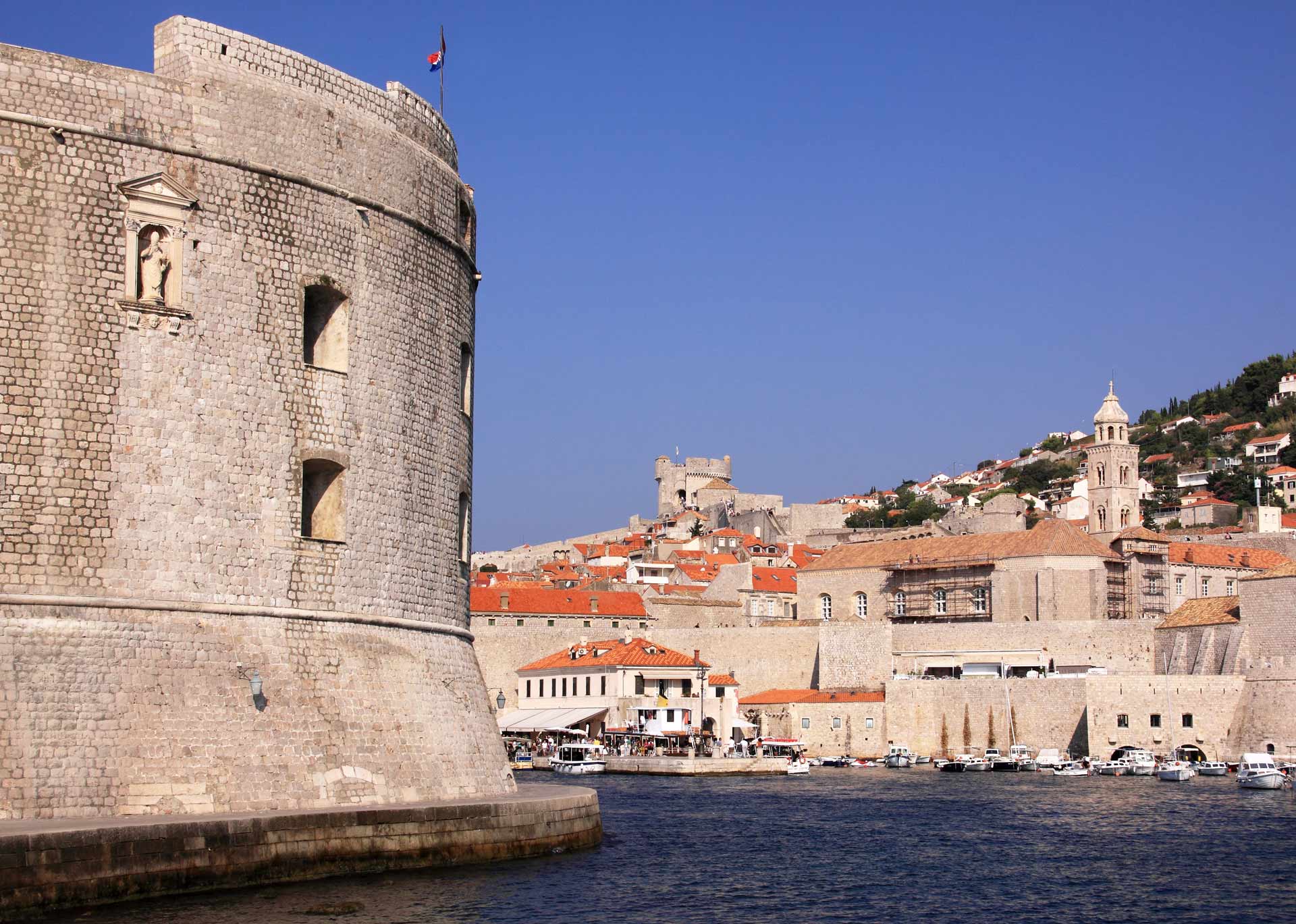
Dubrovnik offers a beautiful combination of picturesque orange rooftops, shimmering blue waters and noteworthy monuments. Enjoy a walking tour through the old walled heart of the city, where all vehicles are banned. Dubrovnik is the best preserved walled city in Europe. Our vehicle drops us outside the Pile Gate, where we visit the old walled town. Some of the beautiful sites we will see (from the outside only) include the Franciscan Monastery, housing one of the world’s oldest pharmacies, the Old Harbour, Saint Laurence Fortress, the Sponza and Rector’s Palace, and more. Afternoon is free to explore on our own. (B)

Day 17: Dubrovnik/Split or Trogir (Drive)

After a leisurely day on the beautiful Adriatic Coast, we drive to Split. Our scenic journey takes us through coastal villages. We make a brief stop at the town of Makarska before reaching the old town of Split or Trogir.
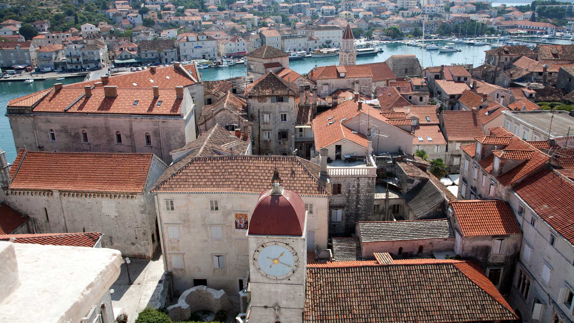
Overnight: Hotel President or Hotel Globo, Split or Hotel Pasike, Trogir (2 nights) (B)

Day 18: Split

Ground floor passage way of the Diocletian Palace, Split, Split-Dalmatia, Croatia

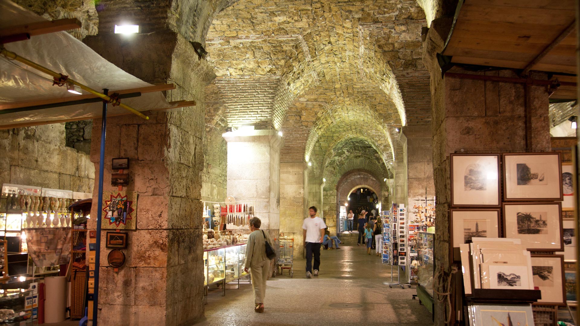
Split is a vibrant city, and the old town features some of the most outstanding classical architecture in the world. At its heart is famous Diocletian’s Palace*, now a UNESCO World Heritage Site. It was in 295 AD that the Roman emperor Diocletian started to build his palace on the Dalmatian Coast. After his abdication in 305, the retired emperor left Nicomedia and settled in the palace. What remains of the palace today is so large that it makes up approximately half of Split’s old town area! We visit the impressive cellars of the palace to get an idea of the original structure. We also discover the Baptistery of Saint John and the Cathedral of Saint Domnius. Afternoon is free to enjoy the traditional markets of Split. (B)

Day 19: Split or Trogir/Opatija (Drive)

Today, we are swept back to medieval times with an exploration of Trogir*, the best preserved Romanesque-Gothic town in Central Europe. The centre of the UNESCO World Heritage Site is Narodni Trg, a creamy white square flanked by the Cathedral, the Communal Palace, and the Loggia, used as a courtroom for town trials during the Rennaissance era. We then visit the 13th century Venetian Cathedral of St. Lovro, located on Ivana Pavla Square. Our next stop is at the Cathedral of St James in Šibenik*. Built in the 15th and 16th centuries, this cathedral flawlessly combines Gothic and Renaissance art. A highlight of this UNESCO World Heritage Site is the remarkable frieze decorated with more than 70 sculptured faces. Our journey continues to Zadar, the ancient capital of Dalmatia. Zadar boasts a variety of architectural styles, with Corinthian columns standing alongside Romanesque churches. We conclude our scenic drive along the Adriatic Sea at lovely Opatija.
Overnight: Hotel Cristal, Opatija (1 night) (B)

Day 20: Opatija/Pula/Rovinj/Porec (Drive)

Loggia with clock tower, Trogir, Split-Dalmatia, Croatia

Our explorations of the Adriatic Coast begin with a tour of Pula, occupied since the prehistoric era. The highlight of Pula is an impressive 1st century Roman Amphitheatre overlooking the harbour. We then continue on to Rovinj, a Croatian town that offers true Italian flavour. Here, the narrow, winding streets of the old town are lined with shops selling local wines, grappa, the region’s tasty olive oil, and truffles. Above the old town, the Basilica of Santa Euphemia watches over the daily activities. The origins of this basilica date back to the Oratory of Saint Maur, a secret place of worship during the time that Christianity was banned. We continue on to the historic resort town of Porec.
Overnight: Hotel Palazzo, Porec (2 nights) (B)

Day 21: Porec

Today, discover Porec. This historic town has fell under the rule of many empires over the centuries, including the Romans, Venetians, and Austrians. The Decumanus main street here dates back to prehistoric and Roman times. We also see the remains of the Roman forum. The highlight of Porec is our visit to the Episcopal Complex of the Euphrasian Basilica*. Dating from the 6th century, this UNESCO World Heritage Site is famous for its gem-studded Byzantine mosaics. Later, we visit the picturesque hilltop villages of Groznjan and Motovun. (B)

Day 22: Porec/Postojna/Ljubljana (SLOVENIA) (Drive)

A scenic drive along the coast brings us into Slovenia, offering dramatic landscapes, medieval cities and more. Our first stop is Lipica Stud Farm. Dating from the 16th century, this stud farm is where one of the world’s oldest cultural horse breeds, the famed Lipizanner, originated.   Our next adventure is a visit to Postojna Caves, one of the largest cave complexes in Europe. Measuring an impressive 27 kilometers long, Postojna is one of the most famous areas in the world for the study of karstic phenomena, and has been a tourist destination for more than two centuries.
Overnight: Hotel Union or Hotel City, Ljubljana (1 night) (B)

Day 23: Ljubljana/Bled (Drive)

Lake Bohinj, Slovenian Alps

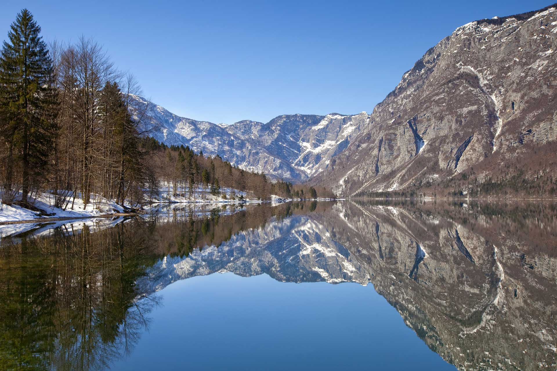
This morning is dedicated to exploring beautiful Ljubljana. A drive through the streets of this sunny city shows us buildings reminiscent of both Vienna and Prague. The difference, however, is that the Slovene capital is tiny by comparison, small enough to be easily visited on foot. We go up to the city's highest point to visit the 16th century castle, then descend to the lower city to see Trg Naradnih Herojev, the square housing one of the world’s newest parliaments. We continue on foot to visit the old town, with its large university and philharmonic hall. Ljubljana is marked by the architecture of Jože Plečnik*, known for his ability to create buildings that seamlessly blended the older city and the needs of a modern society. Plečnik’s architecture was created between World War I and II, and was designated a UNESCO World Heritage Site in 2021. We explore his Triple Bridge across Ljubljanica River, as well as some of the city’s indoor and outdoor markets. After our discovery of Ljubljana, we journey on to Lake Bled. Reflecting the high peaks of the Julian Alps, this romantic lake has always been considered sacred to the locals. We start with a visit to medieval Bled Castle, perched on a cliff overlooking the town. Offering stunning views of the lake, the castle is also home to a small historical museum with artefacts dating back to the time of the Romans. At the shores of Lake Bled, we embark on a boat ride to Slovenia's only island, home to a Baroque church dedicated to Our Lady of the Lake.
Overnight: Hotel Park, Bled (1 night) (B)

Day 24: Bled/Plitvice Lakes (CROATIA) (Drive)

A journey through charming villages and lovely scenery today as we cross back into Croatia and continue on to Plitvice Lakes.
Overnight: Hotel Jezero, Plitvice Lakes (1 night) (B) 

Day 25: Plitvice Lakes/Zagreb (Drive)

Art Pavilion, Zagreb, Grad Zagreb, Croatia

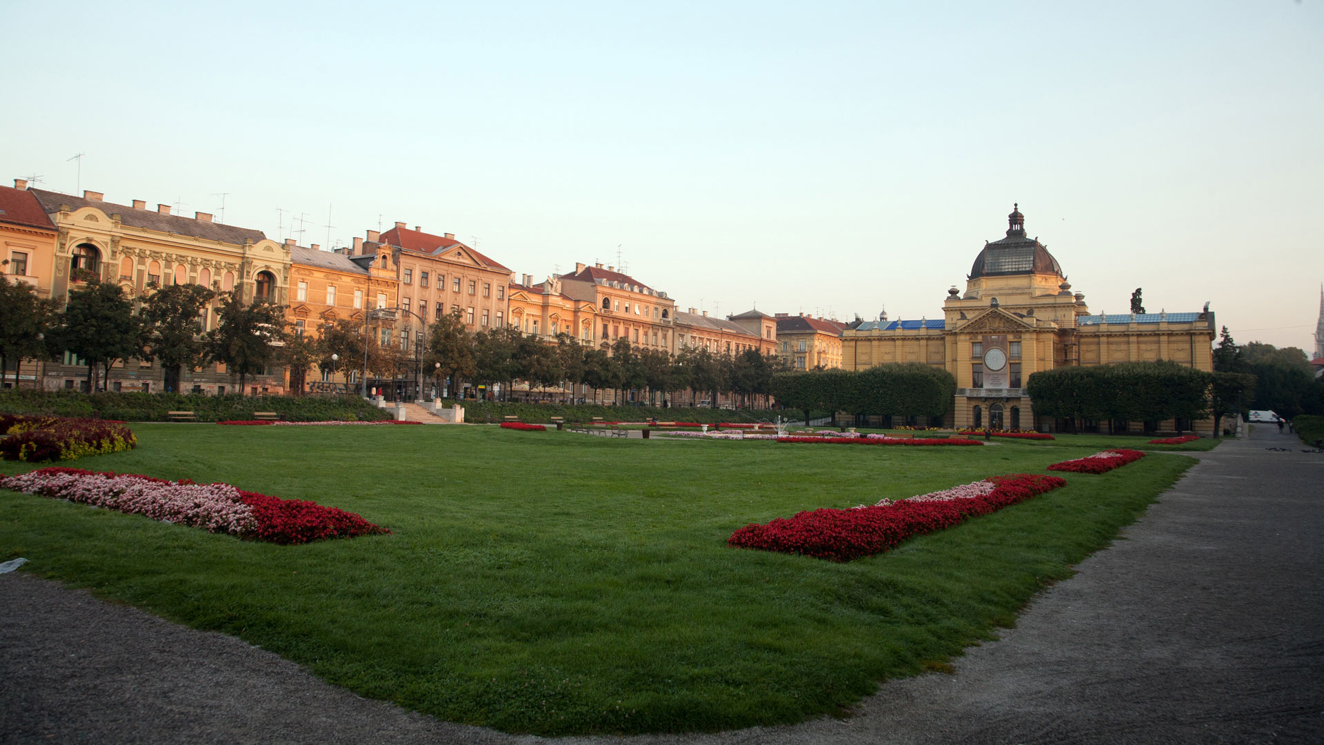
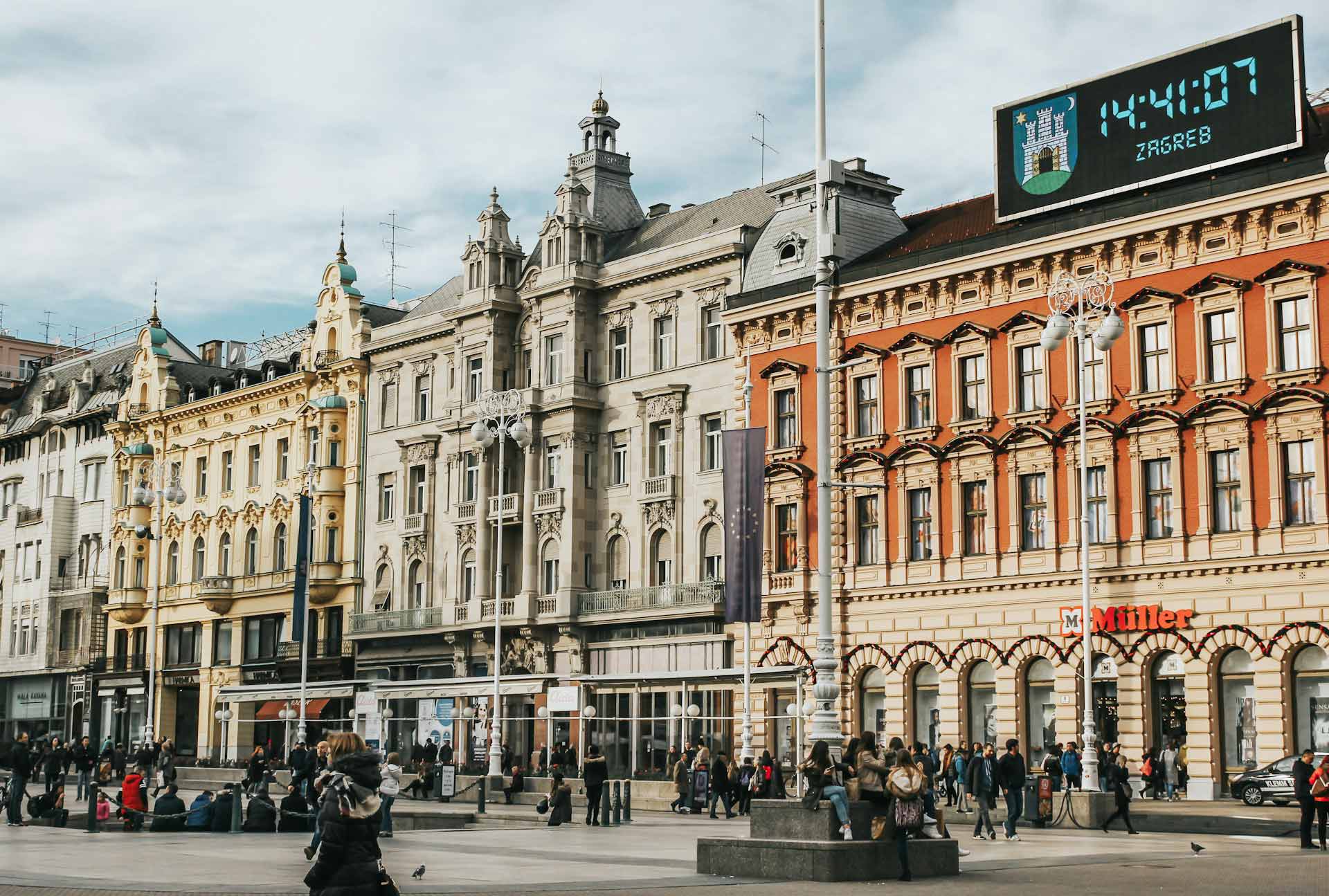
Enjoy the enchanting scenery of Plitvice Lakes*. This UNESCO World Heritage Site consists of 16 terraced lakes surrounded by dense forests, mountains and lush vegetation. Stunning waterfalls connect the lakes, and we may even be treated to clouds of butterflies drifting overhead! After our adventures here, we make our way to Zagreb, known for its medieval sites and café culture. Here, we discover Zagreb Cathedral, the Dolac Market, Saint Mark’s Church, dating from the 13th century, and Lotrscak Tower.
Overnight: Hotel Palace or Hotel Dubrovnik, Zagreb (1 night) (B) 

Day 26: Depart Zagreb 

Completing our remarkable journey through the history in the Balkans, we are transferred to Zagreb airport for our onward flight. Or, extend our adventure with another Bestway tour—Hungary, Romania and Bulgaria are great options! (B)

B=Breakfast, L=Lunch, D=Dinner

Departure Dates & Prices (Segment One)

We accept payments in US$, CA$ as well as in other convertible currencies like EUR, AUD and GBP. Tour prices have been costed in US$. CA$ price shown below is an indicative amount reached at by using the conversion rate at the time of web posting and will be applicable if there is no change in the conversion rate. Should the currency conversion rate change, the US$ pricing will prevail. Bestway Tours & Safaris offers a conversion rate protection. Once full payment has been received and no modification has been made to the tour itinerary, we will honour that rate. For complete payment procedures, please click here

Stay tuned for future dates! If you want to be the first ones to know click here
2024 Per Person on
Twin Sharing
Single Room
Supplement
Departure(s)
May 11; Jul 06; Sep 14    
Segment One (Days 01 – 15) US$ 5795 US$ 895
2025 Per Person on
Twin Sharing
Single Room
Supplement
Departure(s)
May 10; Jul 12; Sep 13; Oct 4    
Segment One (Days 01 – 15) US$ 5995 US$ 995
Stay tuned for future dates! If you want to be the first ones to know click here
2024 Per Person on
Twin Sharing
Single Room
Supplement
Departure(s)
May 11; Jul 06; Sep 14    
Segment One (Days 01 – 15) CA$ 7998 CA$ 1236
2025 Per Person on
Twin Sharing
Single Room
Supplement
Departure(s)
May 10; Jul 12; Sep 13; Oct 4    
Segment One (Days 01 – 15) CA$ 8274 CA$ 1374
  • Both segments are also available on a private basis.
  • For Segment One (Days 01 – 15) the price for a private tour is at an additional cost of 7.5% based on a minimum of 2 person traveling together.
  • Segment Two (Days 15 – 26) is only offered on a private basis. Please contact us for details.

Guaranteed Departures 2024

  • May 11
  • Sep 14

Notes

N/A

Inclusions (Segment One)


Tour Price Includes
  • 14 Nights' accommodation as mentioned or similar, including hotel taxes
  • 27 Meals as mentioned (B=Breakfast, D=Dinner)
  • All sightseeing and transfers by private transportation
  • Services of local English speaking guides cum drivers
  • Entrance fees to museums and sites included in the itinerary
  • 24/7 Local emergency contact
Not Included
  • International airfares
  • Insurance/visas
  • Tips/gratuities

Participants

This tour operates on a minimum of 02 and a maximum of 12 participants

Customised Itinerary

If you would like to have a tour on dates other than the above ones or with a customised itinerary, please contact us and we will be happy to work out an exclusive program for you.

Contact Info
You may e-mail us at bestway@bestway.com or call 1-604-264-7378. Residents of U.S.A./Canada may call us toll free at 1-800-663-0844.

Traveller's Testimonials
What it's like on our Balkan Mosaic tour - A day-by-day travelogue from two Bestway travellers
Bestway travellers Nick and Michaele Stooke of Illinois, USA, joined us on our signature Balkan Mosaic journey in June 2024 and had an incredible time! We've gotten their permission to share their detailed travelogue below, if you want just a taste of what's in store for you on this tour.

June 05, 2024

This travelogue covers our tour through select Balkan countries from 10-26 May 2024.  The Balkan Peninsula is generally considered to be the area of southeastern Europe bordered by the Adriatic, the Aegean, and the Black Seas.  It is a land of diverse religions, races, and ethnic and political influences that range from the Romans, early Slavic empires, the Austro-Hungarian Empire, the Ottoman Empire, communism, and democracies.  Despite these cultural diversities, the people adapt and move on.  For example, the huge mosaic below is 478 yd² (400 m²) and is located over the front entrance of the Albanian National Historical Museum in Tirana.  Anyone who is familiar with communist art will recognize its bold and muscular characterization of workers and historical figures in what is called the “Socialist Realism” style.  The mosaic was created under the communist dictator Enver Hoxha and depicts the historical evolution of the Albania territory.  It included the gold silhouette of a 5-pointed star (to symbolize communism) over the double eagle on the flag.  There was also a large 5-pointed red star behind the central lady’s head, and the man on her right was holding a red book.  When the dictatorship ended, the mosaic chips of the communist icons were carefully removed and replaced.

Our tour was organized by Bestway Tours out of Canada through Dragana Petković of Balkan Expert Tours in Belgrade.  We expected to travel with as many as ten other people, but turned out to be the only two who signed up, so we had an excellent private tour and were well-cared for.  The adventure started with a few days in Belgrade, Serbia, then we drove some 1,500 mi (2,400 km) through the five other countries indicted on the map below.  (The countries we visited and their capitals are listed in black on the map, along with dots indicating some of the places where we stopped.  The maps of the individual countries will fill in the names of some of the places visited.)  Driving is one of the best ways to take in the local sights, culture, and cuisine, and it was our first time visiting four of the countries.  Overall, the region has rich agricultural areas, lush woodlands, beautiful seashores, and some of the most rugged mountain ranges we have seen.

The trip started on Friday, 10 May when we caught a Lufthansa Airbus 330 flight directly from St. Louis to Frankfurt, Germany (with no layovers in a U.S. departure airport).  We were especially fortunate to be on the left side of the airplane looking towards the north.  During the night flight, the aurora borealis was very active, and we were able to snap some photos of a phenomenal display.  In the photo, the aurora shows up as the green and purple hues of what looks like a curtain.  Across the bottom, the light of dawn is coming up over a cloud deck, and the reddish tint of the sunrise is showing through a hole in that deck.

On Saturday, 11 May we landed in Frankfurt and caught a Lufthansa Airbus 320 to Belgrade, the capital of Serbia.  There we were met by our guide, Dragana, who took us to the central section of Old Belgrade where we checked into the Hotel Moskva of Beograd (Belgrade).  In the 1800s, the site had been a farmer’s market and then a modest inn.  In the early 1900s an ambitious construction project with Russian backing was undertaken, and the building in the photo was officially opened on Terazije Square (the officially designated center of the city).  In 1908 it was the biggest privately-owned building in Serbia.  It was two stories taller than the surrounding buildings, so it dominated the skyline of Belgrade and quickly became one of the most prestigious places to stay in the city, as well as a place for many businesses to open offices.  Today it is a 4-star landmark hotel that is near the downtown core, and it is still a stately representative of the elegance of European life the early 20th century.  The halls of the floor we stayed on were adorned with pictures of politicians, entertainers, and dignitaries who stayed in the hotel throughout the years.

Background Information:  The Republic of Serbia has a parliamentary form of government with a prime minister, but its president is the head of state.  The country has been inhabited since the Iron Age, with groups such as the Thracians, Dacians, and Greeks having lived on the land.  A Serbian kingdom was autonomous during the Middle Ages, but it fell to Turkish control hundreds of years before the Ottomans made their successful push into Central Europe.  In the 20th century, the country became infamous for the assassination in June 1914 of Archduke Franz Ferdinand of Austria in the then-Serbian city of Sarajevo – the spark that ignited WW I.  Today it has a population of just under 7 million people who live on 34,116 mi2 (88,361 km2) of land, making it slightly smaller than Maine.  The economy is dominated by a service sector which accounts for 60% of GDP, followed by industry with 32% and agriculture at 8%.  The official language is Serbian that uses Serbian Cyrillic script, but informally Latin and Cyrillic alphabets are both used.  Nearly 85% of the population follows the Orthodox religion, with Catholics, Muslims, and Protestants making up the rest.  The country provides universal health care and free primary and secondary education to its citizens.  The official currency is the Serbian dinar, with $1US≈ 107dinar.  The country has an excellent sports tradition, producing athletes such as Novak Djokovic, currently ranked No. 1 in the world in men's singles tennis.  The flag uses a two-headed eagle that has historical connotations in the region as a symbol of an independent empire (past or present).

After unpacking and a brief rest, the two of us set out on a relaxing Saturday-afternoon walk near the hotel.  We ended up at Republic Square, considered as somewhat of a social gathering place for the city.  The red building in the background is the National Museum of Serbia.  The building started as a financial center in 1903 and was converted to the museum that opened in 1952.  The building barely visible on the far right is the National Theater.  In the center of the square is a statue of the prince on horseback who pushed the Ottomans out of Serbia in 1867.  Today, many Serbians do not remember the name of the prince, and often simply tell friends I’ll meet you at “the horse”.  The stage was set up as part of a celebration of families, and featured a live band accompanying pre-recorded videos and audios of children singing.

On the way back to the hotel we walked along Terazije Street that the hotel is on.  It is normally one of the busiest streets in the old part of the city, but on that afternoon it was blocked off for a bicycle race.  The cyclists followed a closed loop around the widest part of the street that has a median, and the photo captured them making a tight turn around one end of the median.

We returned to the hotel, the jet lag caught up with us, and we slept well that evening.  On the morning of Sunday, 12 May, there was time after breakfast and before our tour for a few photos of another section of the old town neighborhood.  Right across Terazije Street from the hotel is a collection of nondescript office buildings.  After the architectural splendor of the early 20th century, Belgrade became the capital of Yugoslavia under the communist regime of Josip Tito.  After WWII the country embraced a more utilitarian outlook on life as evidenced by the plain façades of these buildings that were designed as part of the post-war reconstruction era.

A few blocks from the hotel is a building that has had an interesting and varied past.  The cornerstone was laid in 1907 for the neo-Baroque style building that was intended to be the House of the National Assembly of the Kingdom of Serbia.  However, the Balkan Wars, World War I, and the Great Depression interrupted construction that was not finished until 1936.  From the time it was opened until 2006 it was the seat of the Parliament of Yugoslavia and then the Parliament of Serbia and Montenegro.  After 2006 it has been the House of the National Assembly of Serbia.  (The factors surrounding this building are indicators of the complicated history of the whole region.)

Across the park in front of the National Assembly building is a building housing the offices of the Presidency of the Republic of Serbia, and it has a history of its own.  Design plans started in 1903 for the New Court palace to house the Serbian royal family, and construction started in 1911.  After WWI broke out, Austro-Hungarian soldiers were billeted in the unfinished palace, and they destroyed much of the interior.  When the palace was finally completed in 1922, the Serbian royal family moved in and lived there until 1934, when King Alexander was assassinated in Marseille.  For almost two decades the palace housed displays of the National Museum.  After WWII it went through years of refurbishment that featured architectural ornamentation in the Renaissance and Baroque styles.  Since 1953 it has been used for the highest executive offices in Serbia. Near Republic Square is an area of the old town that has several pedestrian-only streets that engender a communal atmosphere that is not possible when streets are filled with cars, busses, and trucks.  Some streets have retail stores and kiosks, while others are lined with trees and sidewalk cafés where people can linger to enjoy a social gathering and watch people go by.  As seen in the photo, business was slow on an early Sunday morning.

Around mid-morning, Dragana and her driver Goran picked us up for a tour of the highlights of Old Belgrade and New Belgrade.  Dragana did an excellent job of organizing the entire tour, and she served as our guide in Belgrade.  She was very patient in helping us try to understand the politics, religions, and clashing empires that shaped the Balkan cultures.

Belgrade is situated on a hill overlooking the confluence of the Danube and Sava Rivers, and the older section of the city used the Sava River as its western boundary.  The area west of the river is now extensively developed with new buildings constructed in the post-WWII era.  As a result, most of the newer buildings have the traditional plain communistic look of steel and glass.  However, further upstream along the Danube River is the old fishing village of Zemun that has the Gardoš Tower on a small hill.  The tower is also called the Millennium Tower because it opened in 1896 to celebrate a thousand years of Hungarian settlement in the Pannonian Plain.  Seven towers were built all over the Hungarian part of Austro-Hungary, stretching from Budapest, Hungary to Ukraine, Slovakia, and points in between, with Gardoš Tower being the southernmost.  Ironically, a little over 20 years after the tower was built, the Austro-Hungarian Empire was dismantled in the aftermath of WWI.  The tower stands 118 ft (36 m) high.  Towards the end of the 20th century, it was in total ruins with almost all of the doors and windows missing.  Early this century a group of private history enthusiasts worked to restore the building by referencing original schematics from 1896 – which are kept in the Belgrade City Museum – as their guides to rejuvenate the tower to its original splendor.  From the base of the tower we could look across the Sava and Danube Rivers over parts of the Belgrade metropolitan area.

From the tower we drove back across the Sava River to an older part of the city where the House of Flowers is located.  This is the name given to the estate of Josip Broz Tito who was the communist leader of Yugoslavia from WWII until his death in 1980.  As a term of endearment, some referred to it as the “flower shop” during his lifetime.  The estate has his residence, guest houses, offices, and the photo is of the mausoleum where he is buried under the large slab of white marble.

Background Information:  Josip Tito was a military and political leader whose strong personality was able to unite the ethnic factions of Yugoslavia into one nation.  A devout communist since early in his life, he led Yugoslavia to communism in the late 1940s – but to his own brand of communism.  He split with Stalin and the Soviets early in his political reign and played East and West against each other to his benefit.  By doing so, his international stature was elevated when he became the leader of the 120 countries of the Non-Aligned Movement (NAM) during the Cold War.  After his death, Yugoslavia was ruled by a committee of ethnic individualists, and it was just a matter of time before the former empire split into smaller countries.

The Serbian Orthodox Church has long been the religious foundation of the culture of the country.  Saint Sava (1175-1235), is the patron saint and national hero of the Serbian people since he was instrumental in separating the country from the influence of the Byzantine church.  His body and coffin were burned by Ottoman Turks in 1595 to eliminate all physical traces of his presence.  In the late 1800s there was a movement to build a grand church in his memory.  The photo shows the Temple of Saint Sava that was built on the site on the Vračar plateau where, at one time, he was believed to have been buried.  The first stone was laid in 1935, and after decades of war and communist restrictions on construction of any religious buildings, in 2017 the exterior construction was complete.  Designed to replicate the dimensions and appearance of the Hagia Sophia in Istanbul, the temple is the largest Orthodox church in Serbia, and the top of the cross in the photo is 257 ft (78.3 m) above the ground. Stepping into the interior of the temple was like walking into a giant cavern.  The top of the central dome is 213 ft (64.9 m) above the floor, and there is enough space to accommodate 10,000 worshippers.  In 2019 Vladimir Putin visited the church and announced that the Russian state would finance parts of the mosaic cladding that remained to be added to make a total of 130,000 ft2 (12,000 m2) of gold mosaics.  When we visited inside the temple there was a wedding being conducted, and several other weddings and baptisms were scheduled for that Sunday.

The last major stop of the tour that day was a walk through the most-visited site in Belgrade – the remains of Belgrade Fortress that overlook the two rivers.  The area was fortified as early as 279 BCE.  At its height during the Middle Ages, the fortress had several sections that covered 160 acres (66 hectares).  Due to its location on two strategic rivers in the Balkans, Belgrade has seen 115 wars, and despite its fortifications it has been razed to the ground 44 times.  Most of the ramparts have now been dismantled, but the inside of Stambol Gate, the main entry gate with its 88.6-ft (27-m) clock tower in the photo, is a reminder of how massive the fortifications once were.  Today the fortress is the centerpiece of a collection of green spaces and parks that attract many visitors who stroll the grounds.

We finished touring, had a short break, and then Dragana took us to yet another pedestrian walkway lined with popular restaurants.  We dined at the Dva Jelena restaurant, and enjoyed a meal while sitting outside in the comfort of the night air.

We ordered a delicious sampler platter of three types of meats (a type similar to hot dogs is hidden behind the kabobs and the breaded pork cutlet), accented by side salads, fresh bread, and French fries.  Despite all the walking during the day, we were not able to finish the huge quantity of food.

To top off the meal, the 4-person band serenaded us.  Two accordionists, a guitarist, and a vocalist sang a variety of Serbian folk songs, as well as traditional songs from elsewhere around the Balkans.  It was the perfect way to end an excellent day of touring Belgrade.

Dragana walked us back to the hotel where we thanked her, said farewell, and slept well that night.  In the next segment we will continue our tour on the following day by meeting Zoran, the guide who would drive us on the rest of our journey.  On that day one of our activities would be a ride on a train that was once part of the historic Serbian National Railways structure and is the only narrow-gauge railway still operating in Serbia.

June 10, 2024

On the morning of Monday, 13 May there was enough time after breakfast for a quick walk to a few other sights of the old section of Belgrade. The first stop was at the city’s main train station. It was constructed between 1882-85, and the first train from the station departed amidst great fanfare on 1 September 1884, carrying members of the Serbian royal family. During the golden age of the station during the 1970s-80s, the peak of 150 trains per day was reached, and until 1990 it was one of the stops for the prestigious Orient Express (Paris-Istanbul). The station operated until 30 June 2018, when the last train left for Budapest. Today, passenger rail traffic comes and goes at a new station in the newer part of Belgrade. The plan is to convert the old station into a museum, but the conversion is controversial, and funding has not been available. Controversy also surrounds the giant statue that was dedicated in front of the station in January 2021. The 75-ft (23-m) bronze sculpture was created by a Russian artist and depicts Stefan Nemanja, the legendary founder of the Serbian state who became the Grand Prince in 1166. The ruling politicians of 2021claimed the statue to be a grand monument, while critics claim it looks too much like a Soviet-era mega-size monument. In addition, its price tag of many tens of millions of dinars was said to be reckless spending clouded in secrecy.

A few blocks up from the train station is another historically-interesting building that was constructed from 1957-65. The photo shows what was part of the Yugoslav Ministry of Defense Headquarters. During the Kosovo War, around midnight of 29 April 1999, NATO bombed the building twice as part of an effort to stop the fighting. A cease-fire was subsequently negotiated, and a debate on what to do with the building ensued. The structure was reinforced to keep it from collapsing, and since 2005 it has been a protected monument of culture to memorialize those who died during the conflict.

Back at the hotel we were picked up by Zoran who drove us out of Belgrade and into the Serbian countryside to start our driving tour. We rode in his personal Škoda sedan. The car originated in the Czech Republic, and the company is now part of the conglomerate Volkswagen Group. It was a comfortable ride with plenty of leg room for the back seat and a large trunk. We rode west out of the city following a major 4-lane highway where most of the overpasses were identified as being constructed by one of a number of Chinese companies. We later pulled onto a smaller 2-lane highway where verdant rolling hills dominated the terrain, and we passed the small lake in the photo where the houses were typical of what we would see outside of the cities. They had a concrete skeleton with walls built of hollow clay bricks, all of which was covered in stucco.

As we have seen in other European countries, the signs along the highway were usually in at least two languages. In the photo, directions to four cities are indicated. The top name of each city is in the Cyrillic alphabet used throughout the region for centuries, and the bottom name is the Romanized version. The oval with MNE indicates a city in Northern Macedonia, and the oval with BIH indicates a city in Bosnia and Herzegovina.

A sign that was new to us is in the photo. We have seen signs with the name of a city or village with a red diagonal across it, indicating we were leaving that municipality. This was the first time we have seen the profile of buildings with a red diagonal to indicate we were leaving a congested area.

Our major destination that day was the Mokra Gora area in the Zlatibor Mountains of southwestern Serbia. It is a secluded area where the landscape and farms of the valley have a special atmosphere that reminds many travelers of being in Switzerland, as you will see later. The first stop was at what is called the Šargan Eight railway that operates on a 9.6-mi (15.4-m) narrow-gauge track that is all that is left of a line that once ran from Belgrade to Sarajevo. In the photo, Zoran is pointing out how the name comes from the combination of the little town of Šargan and the figure eight the train makes in the tunnels where the track crosses back over itself to make the steep climb up the mountains.

Although they are not easy to see, the photo shows three tunnel entrances that indicate the engineering challenge of building a railroad in such steep terrain. In addition to numerous tunnels where the track makes a huge turn within the mountain, there are also several bridges that span the gap from one side of a ravine to the other.

At the Šargan station at the top of the mountain the train made a stop so everyone could get off, stretch, and maybe buy an ice cream confection. There were several groups of school children who headed for the gift shop, so we used the opportunity for Zoran to snap a photo of us next to one of the vintage cars that have been restored. The rolling stock from the 1930s was rescued from various railway “retirement” sidings, and no two cars are identical. In fact, the cars, the engines, the tracks, the stations, and even the tunnels and bridges had to undergo significant restoration to make this operation a safe and viable tourist attraction. In the background of the photo is an old steam locomotive that is kept under a protective shed and used every now and then. Otherwise, an assortment of diesel engines makes the short but steep trip several times a day. The train made a few photo stops on the way back down the mountain. The panorama below provides some idea of why the terrain and some of the farms look like they could be in an Alpine valley in Switzerland. On the far upper right side of the picture note the collection of dark brown buildings – later photos will show that to be the unusual lodging complex we stayed in overnight. After the train ride we dropped our luggage at the hotel complex and headed a short distance further west where we left Serbia and crossed into Bosnia and Herzegovina to visit the town of Višegrad a few miles inside that country. We only stayed for a few hours, so the information about BIH will be provided when we make a full visit to the country towards the end of our trip. One of the main attractions of our short excursion was to see the architectural elegance of the Mehmed Paša Sokolović Bridge. Construction of the bridge took place between 1571-77 at the request of Grand Vizier Sokolović, a Serbian who served as a high official in the Ottoman court but never forgot his home region. The bridge facilitated commerce over the Drina River and is considered one of the finest examples of Ottoman monumental architecture and civil engineering. It is 589 ft (179.5 m) long with 11 masonry arches that span 30-49 ft (11-15 m), and several sections have been restored after wars or floods. (The left end makes an abrupt 90° turn onto a ramp that is not visible in this photo.) The graceful bridge is now limited to pedestrian traffic only and is listed as a UNESCO World Heritage site.

Background Information: Mehmed Paša Sokolović had an unusual but very successful career. He was born in Serbia and was initially raised in the Serbian Orthodox religion. As a young boy he was forced into service as an officer and administrator in the Ottoman sultan’s household troops and schooled in the Muslim religion as part of the devşirme levy (also called "blood tax"). This was the fate experienced by many Christian boys during the Ottoman 500-year occupation of the Balkans since the boys had no tribal allegiances that might lead to a palace coup. Sokolović proved to be an exceptional military strategist and capable administrator, eventually rising to the position of Grand Vizier of the Ottoman Empire, second in power only to the sultan. He used his position to help stabilize the Balkans through projects like the bridge.

The second site we visited in Višegrad is an area known as Andrićgrad. It is dedicated to Ivo Andrić, the author who wrote The Bridge on the Drina in 1945. The historical novel (that won Andrić the Nobel Prize in Literature in 1961) describes the building of the bridge and the account of the lives of some of the people in the local communities during subsequent centuries. The photo shows the main entrance of Andrićgrad that was opened in 2014 by the Serbian film director Emir Kusturica who planned to use it as a set for The Bridge on the Drina movie he wants to make (but has not yet).

Inside the walls is a sample of buildings of eastern and western architectural styles that would be featured in the movie. The set includes a caravansary, barracks for soldiers, cafés, an Orthodox church, and an assortment of buildings that looks like it might be used in a governmental function. While we were there, only a few people were wandering around the area, and a small group of children were celebrating a birthday party. The site has also been used for festivals for artists and writers.

After the tour of Andrićgrad we retraced our drive back towards the Serbian border. Along the road we saw several houses: bombed-out reminders of the Bosnian war of 1992-95. The war raged for three years and killed over 100,000 people, even affecting those in little backwater communities in the countryside. Today the concrete and brick walls of many of the structures still stand, while the wooden rafters of the roofs have long since collapsed.

We returned to our hotel which was part of the village called Küstendorf (also known as Drvengrad), built from scratch by Emir Kusturica for the filming of his movie Life Is a Miracle that was released in 2004. The photo was taken looking down main street with the small St. Sava church at the far end. There are cafés and lodging facilities along the street. The area includes a library, an artist gallery, a theater, a sports hall, a restaurant, a cake shop, a swimming pool, and a souvenir shop. Since 2008, the village has hosted the annual Küstendorf Film and Music Festival that draws young and aspiring artists.

The village is set up to replicate the wooden cottages and wooden roofs of the Mokra Gora Valley. Many of the lodging buildings are single units, duplexes, or multiple apartments as in the photo, but all of them are individually shaped to be unique, as well as being uniquely decorated on the inside. Our cabin was just to the right of the sidewalk on the right side of the picture. There is also a main house that has a cinema hall in the cellar and private rooms for the Kusturica family. After dinner in the restaurant, we looked out over the lights of the valley below, and then turned in for the evening. On the morning of Tuesday, 14 May we set out from the Mokra Gora Valley on what would become a day of monasteries. We drove through the area around Arilje, Serbia, a region known for its production of raspberries. Reportedly, last year the country was the largest exporter of raspberries in the world, shipping out about 63,000 tons of berries. As many as 37,066 acres (15,000 hectares) of the crop were grown, and the hills on both sides of the highway were covered by fields. Raspberries are a very labor-intensive crop that needs much care, pruning, and attention. The berries are very fragile, so they must be picked by hand and stacked no higher than about three deep to keep from crushing them. Once they are harvested, the berries can be frozen and processed into a variety of products, with about 95% of the crop being shipped worldwide in bulk as what they refer to as “red gold.”

As we entered a more mountainous region we encountered another local operation. Trees are plentiful in the lush woodlands of southwestern Serbia, so we stopped at a charcoal kiln that is one of the secondary industries of the region. The photo is of a typical brick above-ground charcoal kiln. It uses a process called pyrolysis to heat the wood in a closed container with little or no available air once the door is sealed and a heavy metal lid is placed over the top. The result is charcoal that weighs less and will burn with more heat due to the lack of moisture. This method of treating wood for cooking or for using in industrial furnaces has been a common practice since the Iron Age. This particular type of processing takes about 16 days, with the resultant charcoal being bagged and used for barbecues in the Balkans, or exported to Europe. We passed several brick kilns while traveling about 15 mi (24.1 km) through a heavily forested stretch of road.

After a drive of a few hours on a road that kept getting narrower and narrower, we finally reached the somewhat-isolated monastery of Studenica. Of the many monasteries in the former Serbian Empire of medieval times, this one is the most significant for several reasons. First, it was founded in 1190 AD as one of the oldest monasteries. Second, it was one of the largest and richest Serbian Orthodox monasteries, and it went on to become the political, cultural and spiritual center of medieval Serbia. Finally, it is still active and monastic life has flourished on the site without interruption since the 12th century. As seen in the photo, walls still surround the compound. Residences for the monks are on the left, while the central feature is on the right, the Church of the Mother of God, with its white marble façade and Romanesque and Byzantine architectural patterns.

The church is known around the world for its frescoes that are considered one of the paramount achievements of Serbian art. No photography was allowed inside, so the photo was borrowed from a Web site set up specifically to show the frescoes of several monasteries. Art critics claim that the best fresco in the church is the one that depicts the Crucifixion on the photo, painted on a blue background in 1209. The frescoes cover almost every square inch of the walls and ceiling to explain the story of Jesus to the illiterate masses who could not read the Bible. The paintings have survived earthquakes, fires, and being covered over. As the result of exceptional renovation, most of the colors that show through today are original after over 800 years. On the column on the left side, half of the depiction has white dots on it. These are holes that were chipped into the original fresco at times so new plaster to cover it would stick to the wall.

The frescoes had a set pattern of presentation of Biblical scenes that was similar in almost every church of the early orthodox era. We stepped out of the big church and into the adjacent and smaller Church of the King where we were allowed to take pictures. The photo shows a special painting in the back of the church. These paintings were different in each church and depict the benefactor. In this one King Milutin holds a model of King's Church, representing his offering of the church to God. The benefactors were often the ones who paid for the churches, were crowned in the churches, and were later buried in them.

From that monastery we made a drive to and through the town of Novi Pazar to the monastery of Sopoćani that was built from 1259-70. The site was once a large monastic compound with living quarters, dining areas, and outbuildings. Today only the Church of the Holy Trinity remains as seen in the photo. Due to the threat of imminent invasion, in 1689 the monks fled; the Ottomans attacked, set fire to the monastery, and carried off the lead from the church roof. The brotherhood did not return for over 200 years, and all of the church structure in the photo had to be rebuilt to its current condition. During the early rise of the medieval Serbian Empire, the new Serbian Orthodox Church rose with it, and the royal families built churches and monasteries as icons of the empire’s wealth and new religion. Teams of artists traveled the country painting the frescoes, developing their own style of religious art along the way. The frescoes at Sopoćani were done in a Byzantine style and completed in stages as funds and artists were available. Many of the frescoes were finished during the first artistic period of 1263-68. A few decades later another group was completed, and art scholars believe the last frescoes were finished during the longer span of 1335-71. The frescoes of this monastery are considered by some experts on Serbian medieval art as the most beautiful of that latest period. During an exhibition in Paris in 1961, the Sopoćani fresco “Dormition [Assumption] of the Mother of God” (photo borrowed from a Web site and featured below) was named the most beautiful medieval fresco.

The long drive and the visit to the two monasteries filled our day, so that afternoon we returned to Novi Pazar and checked into the Emrović Raj Hotel complex pictured (taken from the 6-story hotel section). The site includes an events (primarily weddings) hall on the left, a restaurant behind the blue pool, and a lodge on the right.

That evening Zoran made a couple of selections from the menu for us to try some of the delicious local cuisine. After the meal it was another night of sound sleeping. In the next chapter we will cross the border into Kosovo, Europe’s newest country.

June 18, 2024

On the morning of Wednesday, 15 May, we started the day with a breakfast at the huge restaurant of the Emrović Raj Hotel on the outskirts of the city of Novi Pazar in southwest Serbia. The dining area was finished on the grand and elegant scale – somewhat like a modern version of a medieval formal dining lodge

The serving arrangement was something new to us. The waitress who barely spoke English seated us and asked us what we wanted to drink. She brought out some orange juice and then disappeared. We didn’t see a buffet line anywhere and the waitress did not bring us a menu, so we sat there for a while, not sure of what to do or expect. The waitress finally came out from the kitchen and set a huge plate in front of each of us – we could have easily split one plate and had food left over. Not only was there plenty of delicious food, it was halal – prepared in the prescribed manner of Islamic law (an indicator of the region being predominantly Muslim).

After breakfast our touring continued with a walk through the old central section of Novi Pazar, a city with a population of over 70,000. The dominant feature of the center is the remnants of the old fortress that was set up in the 15th century. It was built on a slight rise that overlooks the town center, the several nearby rivers, and the trade routes that went through the town and brought it economic prosperity. The fortress was originally triangular, but today only a slight section of wall is left and the interior has been converted into a park that features the defensive tower, and a small open-air amphitheater where events can be held.

We walked down to the old bazar section of town where the architecture was influenced by the Ottomans during recent centuries. The wooden fountain has intricate woodwork that transforms an otherwise-plain fountain into a work of art. We would see several of these during our trip through the Balkans. The low buildings and the communal setting of the plaza are also indicative of the Ottoman cultural influence.

A few blocks away from the fountain is the Altun-Alem (Golden Gem) Mosque that was initially finished in 1528 along what was then called the Constantinople Road where the caravans would travel with goods for trading. In addition to the mosque, there was a Muslim school on the grounds of the complex. Various churches, mosques, and forts are protected cultural sites in this historic region. The Golden Gem was being renovated, so we were not able to go inside.

In a small plot to one side of the religious compound was a Muslim graveyard. We have seen crosses or Stars-of-David used to indicate a religious preference on a headstone, but this was the first time we had seen a turban used to designate an affiliation.

After touring the old town section of Novi Pazar, we drove south and along the north shore of Lake Gazivoda where we entered Kosovo. We passed groups of NATO peacekeeping forces that are there to help quell some of the differences that still simmer within the country. For example, the signs were still printed in two languages, but, as in the photo, members of the majority ethnicity and language in an area would sometimes black out the other language to show their disdain.

The Republic of Kosovo is the youngest nation in Europe, having declared its independence from Serbia in February 2008 (however, that independence is not recognized by all nations of the world). It is a multi-party parliamentary representative democracy governed by legislative, executive, and judicial institutions. As with Serbia, it is a landlocked country in the middle of the Balkan Peninsula. Its history dates back to the Stone Age, and it was subjugated by the Romans, the Byzantines, the Bulgarians, the Serbians, and the Ottomans. The country has a total population of over 1.7 million that live in an area of 4,203 mi2 (10,887 km2), making it a little larger in land mass than the states of Delaware and Rhode Island combined. The economy is dominated by the services sector, followed by agriculture, mining, and wine making. About 92% of the population is ethnic Albanians, with small numbers of Serbians and Bosniaks. Primary, secondary, and tertiary education is predominantly public and supported by the state. The central government functions as the purchaser as well as the provider of health care services. About 96% of the population is Muslim, with token amounts of Christian religions. The Euro is the country’s official currency (with special permission from the European Union), with $1US≈€.93.

In the afternoon we reached the city of Peć (Peja) with a population of around 48,000 (double that when counting the surrounding area). We were in the heart of the old Serbian Orthodox Monastic region, so there were a couple more monasteries to see before we would finish our day. The first stop was at the Serbian Patriarchate of Peć. Adjacent to the drive into the compound was a bullet-proof metal shed that had been used previously to help protect the religious structure, but it was not used when we drove in. The monastery was created in 1346, and the church is actually a collection of four churches that have been built onto each other throughout the centuries. Today, the 4-church complex and some of the other buildings survive and are used as a nunnery.

Serbia was the major stakeholder in Yugoslavia, and this is where the divestiture of that nation becomes even more painful. When the current Balkan countries were formed, some of them took parts of the Serbian culture with them. For two periods throughout history, this monastery was the patriarchate (equivalent to the Vatican) for the Serbian Orthodox Church. The last use of this site as the patriarchate was ended by the Ottoman Empire in 1766. However, today it is still the greatest mausoleum of Serbian religious dignitaries. As a result, it has special significance to the church leaders such as those pictured in the interior that was borrowed from the Web. Access to the church for them is more uncertain since it is now inside a mostly-Muslim nation.

There was one more monastery to visit that afternoon, and it is significant because most of the various monastery functions are still operating, including agricultural activities in adjacent fields. We drove a few miles outside of Peć to the Dečani Monastery that was founded in the first half of the 14th century. At the entrance there was a guardhouse manned by peacekeeping soldiers due to the number of armed actions against the monastery since it was often used as a refuge by several different factions of the series of recent wars. We had to produce our passports before we were allowed to go into the gated compound. Many of the orthodox sites in Kosovo are under some level of security due to the ongoing religious tensions. There was a special orientation going on inside the church, and Zoran knew and talked to one of the monks, so the monk directed us to go into the white building in the background that has invitation-only access. We sat on the upper balcony to enjoy some liquid refreshment while waiting. The Dečani Monastery has the largest medieval church in the Balkans. Inside, we were allowed to take pictures, and the panorama below shows the extensive nature of the frescoes. The building took 8 years to construct, while the frescoes that cover almost the entire interior took 15 years to complete. Towards the bottom of the picture there are ovals hanging from the massive chandelier. These are ostrich eggs that reportedly repel spiders.

That evening we drove back to Peć and checked into the Dukagjini Hotel that is in an older section of the city. The hotel first opened in1956 and now is in an area of the city where vehicular traffic is blocked, and most of the open space is devoted to pedestrian walkways and green areas. Zoran chose a delicious dinner of local cuisine in the hotel’s very spacious restaurant. In our room that evening we came across the unusual configuration. In many places drawers are not put under sinks since the drawer might be blocked by the plumbing. In this hotel, the drawer had a notch for the drain, and it still had enough space for some of the bathroom amenities.

On the morning of Thursday, 16 May we left the hotel, and a few doors down from it passed a hamburger stand with an amusing play on words: instead of McDonald’s, the name was “Meg Donald.” The city and the surrounding area have an assortment of memorials to the numerous wars that have been fought in the region. Some honor a specific individual, some honor a fighting unit, and some honor victims in general who have fallen. Some memorials are statues, some have small domes, and a few like the one in the photo have geometric shapes. This one pays tribute to five individuals who died in 1998.

We followed an old trade route out of Peć that led towards the city of Prizren and were about half way when we stopped at the multi-arched Terzi (Tailors’) Bridge (in the photo) that was built sometime in the 15th century. It received its name in the 18th century when the local Terzijski (Tailors’) Guild financed major renovations to the structure. There are 11 graceful stone arches from the Ottoman era that support its length of 620 ft (190 m). We walked across the bridge and noticed an unusual feature as seen in the next photo. The roadbed that is 11.5 ft (3.5 m) wide is not level; instead, it rises and falls following the shape of the arches below – compared to the newer bridge on the left with a flat roadbed. The most recent modern restoration was partially sponsored by the UN Development Program, and today the bridge is limited to pedestrian traffic only.

We arrived in Prizren, the second-largest city in Kosovo with about 220,000 inhabitants that are mostly of Albanian descent. The first stop was at Our Lady of Ljeviš church that, in 1307, was built as a Serbian Orthodox church on top of an old Byzantine church – that was built on the site of what was believed to have been an old Roman temple. Throughout its history this current building was converted and used as a mosque, converted back to an orthodox church, bombed, and burned. The church has been closed for many years, so Zoran took us along the perimeter wall where we could see the side of it by looking through the concertina wire. In 2020 the Serbian government paid for exterior restoration of the site. We were pleasantly surprised when we walked around the front and found the building to be open. We checked in with the guardhouse across the street and left the officer our passports before we could go into the church. Two specialists were inside assessing the progress of the interior restoration, and they provided a tour of some of the work that has already been done. The photo shows that much has been completed, but there is much yet to do. Some of the walls were plastered (or painted) over, bombed, or burned, so the restoration is a slow and painstaking process that requires a level of artistic talent with frescoes that few people have today. (Compare the number and condition of the frescoes in this church with those of the Dečani Monastery pictured earlier.)

Leaving the church, we walked around the old part of Prizren that features bridges across the Prizren Bistrica (River), mosques and minarets, buildings with Ottoman architectural features, a Turkish bath, and even a few churches of Christian denominations. We then found the complex of buildings that were used for the first meeting of the League of Prizren in 1877, and the photo shows the statues of the main organizers and leaders of that movement. As part of the ongoing struggle for nationalistic independence in the Balkans, the League proposed the peaceful formation of an Albanian nation independent of the Ottoman Empire. After being denied, within a few years that initial position changed radically and resulted in demands for an independent Albanian state and open war against the Ottomans. When the Albanians lost that fight, the League was suppressed and disbanded in 1881. However, it is symbolic of the myriad factors that have historically influenced the cultures of the Balkans – and often still do so today.

After the walking tour of Prizren, we drove to Pristina, the capital and the economic, financial, political, and trade center of Kosovo, due to its location near the center of the country. It has a population of almost 200,000 that is mostly of Albanian ethnic origin. The city suffered peripheral attacks during the Kosovo war at the end of the last century, and ethnic violence in the post-war era when there was widespread retribution against the Serbs that were defeated during the war. We parked in an old sports arena had been repurposed as a downtown garage and started a walking tour. Across from the main square, the photo shows what is left of the Grand Hotel Pristina. During the most-recent war it was the headquarters of the international press corps, and many of the broadcasts about the war came out of this building. As with many structures within the city, today several of its facilities have been neglected, and it ranks as a 2-star hotel at best.

After walking around several monuments, mosques, and churches, we drove by one of the most unique buildings in the city – the National Library of Kosovo that was inaugurated in late 1982. The picture shows some of the 99 domes of different sizes that are said to be a blend of Byzantine and Islamic architectural forms. In addition, the whole building is covered in a metal lattice that represents a fish net. During the latest war the building was occupied by Serbian forces, many Albanian archived documents were destroyed, and the interior was left in ruins after being used as a command center. Today the library hopes to rebuild most of its archives, convert the documents to a digital format, and reactivate or establish additional libraries throughout the country. We then drove out of Pristina, headed for North Macedonia. A short distance from the city we made a final stop in Kosovo to visit one more Serbian Orthodox monastery. Fortresses and monasteries were built of stone, so these structures have stood the test of time (and warfare). The Gračanica Monastery was built in 1321 during the initial expansion of the Serbian Orthodox religion throughout the Balkan region, and many of the frescoes were added during the ensuing decades. The building has alternating courses of brick and stone and is one of the finest examples of Serbo-Byzantine architecture. During its first century it was attacked by the Ottomans several times, sacked, and burned. Today, the church in the photo is all that remains of the monastic compound, and it is on UNESCO's World Heritage List.

Inside, no photography was allowed, so the photo was borrowed from the Web. It provides a good example of how the rough-cut construction stones were plastered over and the frescoes were added to portray every possible aspect of the story of Christ, as well as portraying a few of the benefactors of the early churches. It is fascinating to think that this artwork is over 1,100 years old.

After the visit at Gračanica we drove to the southern border of Kosovo where we entered the country of North Macedonia. However, we will save that part of the trip for the next segment that will feature a walking tour around Skopje with its extensive collection of statues that has brought it increased tourism – but also criticism of the collection that some consider to be excessive.

June 23, 2024

In the late afternoon of Thursday, 16 May we crossed the border into North Macedonia. (Not to be confused with the historical region called Macedonia that once included Greece and parts of six other Balkan countries. Due to a dispute with Greece over the name, the country of Macedonia changed its name to North Macedonia in 2019.) We stopped in the capital city of Skopje, Zoran’s home town, where he took us to the Hotel Solun, but not to just any room – he booked us into the spacious Grand Suite. It also had an alcove with a bathtub on claw feet, and a bathroom with a large walk-in shower. We felt like royalty and gladly would have stayed there for the rest of the tour.

Background Information: The Republic of North Macedonia is another of the three landlocked countries on the Balkan Peninsula. The government is a parliamentary republic with an executive branch composed of a coalition of parties from the unicameral legislature, along with an independent judicial branch. Its 1.8 million population lives on 9,928 mi2 (25,713 km2), making it about the same size as the state of Vermont. Its historical personalities include Alexander the Great and Mother Teresa. It has a flat tax rate of 10% to help encourage foreign investment in its economy that produces automobile parts, machinery, mining products, and some agriculture. The primary ethnic groups are Macedonians and Albanians, with small amounts of several others. About 60% of the population is Christian, along with about 32% being Muslim, to make up the major religions. The country provides its citizens a universal health-care system, and free primary and secondary education. The currency is the Macedonian denar, with $1US ≈57.6 MKD.

On the morning of Friday, 17 May we had breakfast and checked out of the Hotel Solun to start our walking tour of the capital city of Skopje (sounds like Scope-yah) and then head towards Lake Ohrid. The first stop was at the Macedonian National Theater. At ground level outside the theater there are several statues that depict select characters from a few popular plays, and the building façade has a stately neo-classical appearance. However, it was the statues on the roof that caught our attention. The figures were dressed in classical Greek outfits, holding an orchestral instrument, and wearing tunics of gold. Then Zoran told us this was just the beginning, and there were hundreds of additional statues to admire.

Background Information: In 2010 “Skopje 2014” was announced as a bold project to add an artistic and architectural aspect of culture to the capital city by creating a Macedonian identity with new buildings that would follow stricter earthquake standards. As a result, there are estimated to be upwards of 250 statues, with critics citing the millions of MKDs spent on the project, while comedians ask if there are more statues than people in the city.

Near the Stone Bridge across the Vardar River in the center of the city is the monument to Saints Cyril and Methodius. They were brothers who served as missionaries to bring Christianity to the Balkan region. In addition, in 863, they began the task of translating the Gospels into what is now known as Old Church Slavonic that could be understood by the people of the region who could not understand the church’s Latin. The brothers devised the Glagolitic alphabet that a century later evolved into the Cyrillic alphabet. On the left side of the photo is one wing of the Museum of Archaeology that is adorned by majestic Ionic columns to portray the Macedonian classical look.

The Stone Bridge leads across the river to Macedonia Square, the center of the city. The square is the site of festivals and special events. While we were there, red kiosks in the photo were set up to display accomplishments of various schools and clubs. The central feature of the square is the massive statue of Alexander III of Macedonia (also known as Alexander the Great) riding his mighty stallion Bucephalus. The 30-ton bronze statue stands 92 ft (28 m) tall and dominates the square. In addition, the area around the square also has a collection of ground-level statues (a few of which can barely be seen in the photo).

We walked down Macedonia Street towards the old train station and went by the Memorial House of Mother Teresa. The Catholic saint and Nobel Peace Prize laureate was born in Skopje near this location in 1910 and lived for 18 years in a house that no longer exists. The memorial house opened in 2009 as somewhat of a replica of where she grew up, and it includes a museum with artifacts from the saint and information about some of her family members.

We continued down the street to the train station that was first opened in 1940. On July 26, 1963, Skopje was struck by a magnitude 6.1 earthquake that lasted 20 seconds. In its aftermath, over 1,070 people were killed, over 200,000 were left homeless, and around 80% of the buildings in the city were destroyed or damaged. The picture shows the clock on the station that stopped at 5:17 that fateful morning when the quake struck and the station was partially destroyed. Today the building is used as the Museum of the City of Skopje to show its development since the days of its early settlement in 3000 BC.

After the earthquake, the city was rebuilt in the Yugoslav communist era when plain concrete was the most popular construction material of choice. Recently, in order to infuse the city’s buildings with classical aesthetics, faux façades were put on some of them. In the photo, cornerstone caps were added to the surface of the blocks. Over the years, the caps have faded, some of the circles covering the screw holes are showing up, and a tap on the caps results in a hollow sound from the thin plastic material used to create the look.

There is another monument that is on as grand a scale as the statue of Alexander III. The Porta Macedonia memorial arch was completed in 2012 as part of the “Skopje 2014” project. The arch stands 69 ft (21 m) tall and was dedicated to 20 years of North Macedonian independence. Scenes depicting the history of the country are carved into marble, and statues are displayed on and near the structure. Looking through the arch, the statue of Alexander the Great is visible in the background down a pedestrian promenade.

We left the part of Skopje that earned it the title of “City of Statues” and walked back across the Stone Bridge towards Skopje Kale (fortress) on the bluff overlooking the city and the river. We were immediately in a different era and environment as we went into the bazaar that is the modern-day embodiment of the Ottoman historical influence on the region’s culture. The cafés and little shops spilled out onto the pedestrian-only walkways and there was a communal atmosphere that could be felt.

A slight distance before reaching the fortress is the Macedonian Orthodox church called the “Ascension of Jesus.“ It looks somewhat nondescript from the outside, having the appearance more of a one-story utility building. The reason is that it was constructed in the mid-16th century during the Ottoman occupation. Ottoman authorities reluctantly agreed to allow the church to be built, but one of the restrictions was that it should be lower than the nearby Mustafa Paša mosque. The result was a phenomenal structure that might be referred to as an “underground church” since the main floor is 6.5 ft (2 m) below ground level. The interior is exquisitely decorated, and the photo shows one of the panels of the intricate and ornate hand-carved walnut iconostasis that extends across the front of the church. Many consider the collection of carvings to be a one-of-a-kind work of art.

After the visit to the church we went to the fortress that was first built by the Romans. Basically only the exterior walls remain, today offering a view over the city. Coming back from the fortress we went to the Mustafa Paša mosque. It was built in 1492 and stands mostly as it was when constructed over 500 years ago. As an interesting aside, in 2011 the mosque completed a five-year renovation that was funded by the Turkish government.

Friday prayers finished just before we arrived, so we were able to go inside the main hall that was empty. In the center of the far wall is the mihrab, the niche in the wall that indicates the qibla, the direction of the Kaaba in Mecca (towards which Muslims should face when praying). To the right of it is the minbar, the pulpit where the imam stands to deliver sermons. The walls were plain white with gray floral motifs in the upper corners below the dome, and two plaques of Arabic script.

After leaving the mosque we walked back through the bazaar to finish our tour of the city and then began our drive towards Lake Ohrid. In the town of Tetovo we made a side excursion to the Šarena Džamija (Painted Mosque). It is somewhat unique in that it has a square roof rather than an exterior dome. In addition, the exterior is painted in bright floral patterns rather than being plain. On the left is a Türbe, the mausoleum of the two sisters from Tetovo who financed the construction that was completed in 1438.

The interior of the mosque is even more unusual in that it has bright paintings rather than geometric designs. Unlike the oil-based paints used today, more than 30,000 eggs were used to prepare the paint and glaze that went into the elaborate decorations.

The close-up below of the ceiling and upper walls shows the unusual details of a combination of Arabic script, floral designs, cityscapes, and landscapes. True to the Muslim religious guidance, there are no depictions of any individuals. This was the first time we had ever seen a mosque with this type of décor.

From Tetovo we continued our drive south and arrived at Lake Ohrid along with many holiday travelers who like to spend a weekend there. We checked into the Villa Dea hotel that is situated overlooking the lake. We were fortunate to be on the top floor in the room with the balcony on the right corner of the building.

From the balcony we could look out over the promenade that is adjacent to the lake. Our view also included the older central section of Ohrid, with Samuil's Fortress situated on the top of the hill overlooking the town. It was a peaceful and relaxing setting. That evening Zoran walked us a short distance towards town along the promenade for dinner at the Belvedere Restaurant. We had a delicious meal outdoors in the shade of the trees where a band serenaded us. Then we stepped just inside the restaurant to catch the young performers who put on a high-energy assortment of traditional folk dances. The inside of the restaurant was filled mostly with groups of tourists from Turkey.

After the show we walked back to the hotel to close out an amazing day of seeing a variety of attractions. In the next segment we will continue our visit in Ohrid with a walking tour of the old-town section.

June 29, 2024

Saturday, 18 May was a beautiful and serene morning along the promenade of Ohrid, a resort town in North Macedonia. Zoran met us for a walking tour of the old section of town, and started with breakfast at a local bakery. The city dates back to around the 4th century BC, and it has a history of being continuously occupied since then, making it one of the oldest communities in Europe. Today it is the largest city on Lake Ohrid. It was once a major religious focal point of the southern region of the Balkan Peninsula with 365 religious structures. A small church is pictured in the background of the photo. The local saying was that a person could go to a different church every day of the year, but we will feature only a few of them. The street light hanging on the pole above the bicycle is unique to the town.

The street light shape is representative of the style of Ottoman-era houses built in the early 1800s that had bold dark-stained timbers that framed exterior walls of white stucco. The Kanevce House was used as the model for the novel street lights. The street-level floor was often tight and narrow, but the upper floors spread out to offer more space. The top floor was large enough to accommodate gatherings for celebrations the owners may not have wanted the Ottoman occupiers to see, and the house had a distinctive saddle-shaped roof.

One of our first stops was at the National Workshop For Handmade Paper. The proprietor showed us how he mixes selected ingredients to make a paper “soup,” then he drains, strains, and dries the paper into a thicker heavyweight product. Even more fascinating was his demonstration of what he does with the paper. He prints on it with the Gutenberg press. The press is one of only a few known to still exist in the world, and perhaps is the only one that continues to be used to print text or images by hand as was done hundreds of years ago. Local artisans prepare plates with engraved images that the printer then uses in a manner that many consider to be a lost art. The yellow plate is on the left, and the printed white image of a street scene in Ohrid is on the right.

In about the center of the town is the Church of Saint Sophia, one of the larger churches in the city, and one of the most important religious monuments of North Macedonia. The history of the church is indicative of the historical turbulence of the entire Balkan region. In the early days of Christianity, a cathedral was built on the site, but it was demolished by barbarian Slavs in the 6th century. After the Bulgarian Empire converted to Christianity, the core of the current church was built in the 10th century. The structure was later expanded and became the Archbishopric of Ohrid. During the rule of the Ottoman Empire it was converted into a mosque when a minaret was placed on top of the octagonal tower. When the Ottomans were defeated in 1912, the building was converted back into an Orthodox Christian church that was extensively restored after WWII. While we were there, preparations in the lower right corner of the photo were underway for a wedding in the outdoor courtyard of the grounds.

On the inside, the proportions of the structure and the collection of frescoes is impressive. The enduring aspect of a fresco is that the paint is applied to wet plaster, so the pigments slowly soak into the plaster. The fresco can be painted over or plastered over, but the pigments remain as part of the original plaster. If the surface covering can be carefully removed, the pigments in the plaster will show through as seen on the ceiling and some of the walls.

A few blocks from the church is the amphitheater. It appears to be a traditional Roman theater, but archeologists have dated its construction to about 200 BC as a Hellenistic theater. It was used for plays, gladiator fights, and persecuting and executing Christians. The disdain for the site from the later Christians led to the lower section being covered over and forgotten. Local construction in the 1980s uncovered large stone blocks with carvings of the Greek god Dionysius, archeologists were called in, and the theater was subsequently uncovered. With only the lower section preserved, its original total capacity cannot be determined. Today the facility is used for plays, concerts, operas, and ballet performances.

Near the amphitheater is the Church of Holy Mary Peryvleptos pictured in the background. It was built in 1295 as a typical example of what is called the Byzantine style of architecture. However, much of that architecture is hidden behind a cloister across the front entrance that was added in the 14th century and enclosed in the 19th century. The interior of the church suffers from neglect that has led to moisture and salt intrusion that is damaging many of the frescoes. In addition to the church, the compound features a separate Gallery of Icons that were collected from several religious sites in the area. The icons were cleaned of layers of dark soot generated by centuries of burning icon lamps and candles. Today they are displayed in the gallery that is environmentally controlled to protect the colors and details of the artwork from hundreds of years ago. (No photography was allowed inside the church or the gallery.)

From the grounds of the church we looked across the theater to Samuel’s Fortress that dominates the promontory of the old section of the town. Fortifications on the site are estimated to date back to 400 BC, possibly built by Philip I of Macedonia (father of Alexander the Great). In the 10th century, the Bulgarian king Samuel decided to make Ohrid the capital of Macedonia, and added to the old defenses that were already there. After subsequent centuries of neglect, a major restoration project on the fortress was undertaken in 2000 when the exterior walls were rebuilt. Very little inside the fortress was refurbished, but the space was cleverly used to house the buried water tank that supplies the city. The tank is under a slight rise that is used as an elevated stage for concerts and other productions.

We try to collect a small souvenir from each country we visit, and Zoran suggested a filigree butterfly featured in many jewelry stores in North Macedonia. Filigree is metalwork usually shaped from silver or gold wire. The art form dates back to 2500 BC, and it was especially popular in the region during the Ottoman occupation, the skill often being passed down from generation to generation. In Skopje we bought a butterfly about the size of a large coin. On a trail behind the fortress we came across the one pictured. The gentleman who created this was tired of his previous occupation, so he watched several YouTube videos and taught himself how to make filigree in about six months. He uses wires of different colors and just a touch of super glue to hold his creations together until he can mount them. The results are colorful and stunning pieces of art – this one is about 5” x 5” (12. 7 cm x 12.7 cm).

No trip through the former Yugoslavia would be complete without mentioning the old Yugo car. The production run was from 1980-2008 as an inexpensive car with good gas mileage. It had dispersed component production facilities throughout the country, with seat belts, locks, and mirrors that were produced in Ohrid. The one in the photo was parked down the hill from the fortress. The car was introduced to the U.S. public at the Los Angeles Auto Show in 1984 at a price of $4,500 and was sold in the U.S. from 1985-1992 when its market share dropped due to safety and quality issues in the post-Yugoslavia era. Parts are still readily available in the Balkans. (Some people may remember Paul Shanklin’s song “In a Yugo” that was a parody of the Elvis’ hit “In the Ghetto.”)

The trail continued down from the fortress to an area of extensive foundations that are believed to once have been a school and monastery. St. Clement brought Christianity to the region and used the facilities to teach the Old Church Slavonic language and the Glagolitic alphabet to his followers. The photo is of the Church of Saints Clement and Panteleimon that Clement is thought to have designed. Much of the structure was destroyed over the years, and it was rebuilt in 2000-2002, mostly using materials and hand tools similar to those used in the original church that was constructed in the early 10th century. (St. Clement eventually devised the Cyrillic alphabet and is the Macedonian Orthodox patron saint of Ohrid.) We could not go inside the church due to a wedding that was being conducted there.

Our last visit to a religious site that day was to the Church of Saint John the Theologian that is set near the water of Lake Ohrid. That Saturday was busy at many of the churches, and we could not go inside this church due to another wedding. The outside was similar to the Byzantine-style building we had seen earlier, but this one from around the 13th century is an exceptional collection of brickwork patterns that masons used during that era. The arches have a special pattern, the walls next to the arches feature a special pattern, and a wide band over the arches has its own special pattern.

During the walk back through town to end our day of sightseeing, we noticed an additional unusual architectural feature. The land for the houses is broken into small lots, so most of the buildings in the older section have multiple stories. To gain more space in the house, some of them were expanded on each successive floor as mentioned about the Kanevce House. In a few cases, the upper floors were expanded until buildings met. The photo shows how this could happen and create a tunnel out of the lower roadway. The result was more space for the upper floors, while the road was somewhat protected from the sun, wind, and rain.

As we were about to cross the main street along the lake and return to the hotel, we became spectators for an automobile parade. Many countries have their car aficionados, and some of them showed up in Ohrid driving their old Citroëns. The photo shows a few of the Citroën 2CV variants that made their way through the city.

Background Information: The French Citroën automobile company started in 1919. The model 2CV had a production run from 1958-90 as a low-cost, low-maintenance, and low-horsepower (9 hp on the first model) car that was very practical in post-WWII Europe. Similar to a VW Beetle, it has an air-cooled engine, but it is in the front – connected to front-wheel drive. A total of more than 3.8 million units were sold, making it the world's first front-wheel drive car to become a million seller. Today there are several Citroën clubs throughout Europe, North America, and other locations that hold special rallies at tourist destinations like Lake Ohrid where the members can gather and swap car stories.

That evening was quiet with dinner at a local restaurant overlooking the lake. Then it started to rain, and we closed out the day by watching from our balcony as waves of rain came in across the lake and flooded several streets. On the morning of Sunday, 19 May we left Ohrid and headed west around the northern end of the lake and into Albania. We asked Zoran about a souvenir representative of Albania, and he said “a bunker.” Both of us heard him, but the word did not register, and we gave him blank stares. Then he explained the story behind Albanian bunkers. Some 780,000 concrete bunkers were built throughout the country during the 1960s-80s under Enver Hoxha’s communist government that adopted a “bunker mentality.” This was based upon an ideology that it was Albania against the rest of the world. As a result, the cities, the borders, and areas throughout the countryside look like the photo that features the concrete domes of two of the old bunkers. Today most of the bunkers are abandoned, but some are used for storage, some are used as dwellings or cafés, and a big one in the capital city is a museum.

Background Information: The Republic of Albania is on the west coast of the Balkan Peninsula on the Adriatic and Ionian Seas. In 1998 it transitioned from a communist dictatorship to a sovereign parliamentary constitutional republic with a separation of legislative, executive, and judicial powers. The country has a population of 2.4 million (averaging 3 people per bunker) that live on 11,100 mi2 (28,748 km2), which makes it slightly larger than the state of Massachusetts. The economy is based upon agriculture, textiles, mining, cement manufacturing, and tourism that is driving a growing service sector. Ethnic Albanians make up 82.6% of the population, with single-digit percentages of other ethnic groups. Islam is followed by 51% of the people, Christianity or non-denominational preferences makes up about 30%, with small numbers of other religions. The citizens have universal health care access and free primary and secondary education. The currency is the lek, with $1US≈93L.

As we entered the country, we went through the little town of Prrenjas that had been a site for mining and processing nickel. When communism collapsed, the facility here with its production inefficiencies could not compete on the open world market, and it was one of many manufacturing sites in the country that were abandoned. Today, all that remains are the two towers (the one on the left stands 170 ft (52 m) tall) that appear to be covered with pink polka dots. However, the spots are actually ladybugs –1,380 of them that are said to symbolize femininity and good fortune.

We continued driving to the city of Elbasan where we stopped at a castle that was originally built in the 4th century AD. The walls that are 10 ft (3 m) thick were destroyed and restored several times throughout history. The biggest difference between this castle or fort and the other ones we had seen on the trip was that this one was fully repurposed and updated on the interior. The view from outside provided little indication of what we would see inside. The photo shows part of the old stone wall on the far left, but there was also an amphitheater, a restaurant (on pillars above excavations of some of the original foundations), a café, gardens, and other attractions. It was an impressive way of making the area functional and pertinent. After a walk around the inside of the Elbasan Castle, we continued our drive to the south and the city of Berat. This is a good place to take a break, though, so our tour of what some have called the “City of 1000 Windows” will start the next chapter.

July 06, 2024

During the morning of Sunday, 19 May we drove through the town of Elbasan, Albania on our way towards the capital city of Tirana. However, first we would head south to take in the sights of the little town of Berat. Near the town we passed the apartment buildings. They are typical of those we saw from the country’s communist era. The two on the right are still occupied, but the one on the left appears to have been abandoned. Life was austere under the Enver Hoxha regime because simple accommodations and public transportation were deemed to be adequate by his repressive communist administration.

The history of Berat dates back to before Hellenistic times and features almost every culture that has come from the east or the west. As with many towns and cities in the Balkans, there is an old fort, a few Ottoman mosques, and a few Byzantine churches, each telling about a chapter of the history. These cultural artifacts have earned the city of about 60,000 special recognition as a UNESCO World Heritage Site. Our tour began at the Gorica Bridge, one of the oldest Ottoman bridges in Albania. In 1790 a wooden bridge was originally built, but in the 1920s the bridge in the photo replaced it. The 7-arch bridge is 423 ft (129 m) long, 17 ft (5.3 m) wide, and spans the Osum River that runs through the city.

From the bridge we drove to the fortress perched on the steep hill that dominates the town. A small part of the interior of the citadel from the 13th century is empty, but much of its wall encircles houses and buildings that are still in use today.

The features in the fortress include gift shops, restaurants, cafés, religious buildings, actual residences, guest houses, and museums. Most of the streets are only wide enough for pedestrians, motorbikes, and donkeys.

The first site we visited was the Church of the Dormition of St Mary, one of about 20 churches that were once inside the protective walls. We stepped down into the entrance of the church at the left end of the portico and were surprised to find a spacious two-story structure.

The interior of the church was ornate, but decorated with fewer frescoes than what we had seen in many Serbian churches or monasteries. The iconostasis across the front was made of hand-carved wood, as was the pulpit on the left that was raised well above the surrounding floor for audibility and visibility. In addition, in an area where no photos were allowed, there is the Onufri Iconographic Museum. It is named after Onufri, the 16th century Archpriest of Elbasan who became the most important painter of Orthodox murals and icons in the early post-Byzantine era in Albania. (For art aficionados, he used special dyes to create a shade of red that has become known as Onufri red; but he never shared the recipe, so his color went with him to the grave.) The museum has 176 objects created by Albanian iconographic painters who worked in the 14th-20th centuries.

At a lookout point in the fortress we were able to take in an aerial panorama of Berat that was below us. In the photo the Osum River separates the Gorica section from the rest of the city that is below the bottom of the picture. The Gorica Bridge we had first visited is on the far right. The city was built of houses using the Ottoman architectural affinity for windows, and the multiple windows have led some to call it the “City of 1,000 Windows.”

Background Information: The town of Berat is somewhat isolated, a geographical situation exploited during the communist era of the 1950s when few people were allowed to have cars. Some political dissidents, or relatives of those who had fled abroad or sympathized with Tito’s Yugoslavia, were deported to Berat. Each day, these individuals were required to sign up at the Security Office or with the police, and they could not leave the local area without permission.

After the visit to Berat Fortress, we drove north to Tirana, the capital city of the country. On the outskirts of the city we passed the Amadeus Palace Hotel & Casino. This exquisite hotel has a grand mixture of Baroque and neoclassical features and was built in the early 20th century. It has undergone meticulous renovation that carefully preserves the original charm, but Zoran said that, during all the recent times he has driven by it, it remains in the “still to be finished” mode.

As we drove into the capital we noticed an interesting feature of the traffic-control system. In the photo, the traffic light is red, and so is the pole and the supporting arm. When the traffic light turns green, the lights on the pole and arm also turn green. This is one of three aspects of a new system: the lights are more visible to the traffic, they use LED bulbs to burn less electricity, and “smart lights” sense the traffic to adjust the light time to better manage the flow.

We enjoyed a delicious meal at a local restaurant that evening, then settled in for the night. On the morning of Monday, 20 May the day started with a drive from the capital to the Adriatic Sea coast to visit Durrës, one of the oldest cities in Albania, and one of the major ports on the Adriatic. Our tour started with a visit to the Roman amphitheater that was built in the 2nd century AD with a capacity for 20,000 spectators. It is 371 ft (113.2 m) wide and the rear seating was once 66 ft (20 m) high. (For a size perspective, there is a crowd of about 50 people standing in the middle of the top back of the seating area.) During the 16th century in the midst of the Ottoman occupation, the amphitheater was filled in. Various efforts at excavation and restoration have gone on during the last 60 years, but the work has been slow, sometimes exposing the project to atmospheric conditions that have been more destructive than when the site was buried. Under the seating in the amphitheater, the enduring nature of Roman brick and stone construction is evident. The restoration effort has done an excellent job of presenting the layering of these two construction materials.

A short distance from the amphitheater is an older regal section of the city that is only a few blocks from the beachfront along the Adriatic Sea. The Hotel Epidamn Boutique and Spa is an example of the elegance of some of the older facilities. At one time the building was the French embassy, and the decor inside continues a neo-classical elegance that can be seen on the outside.

From the area of the Hotel Epidamn, we went down to the beach and walked along the promenade. It was the off season, and Zoran explained how tourists from Italy come here by the thousands during the summer to enjoy the cheaper cost of food and accommodations, as well as the sunshine. The photo was taken from a hotel and restaurant at the end of a long pier, looking back towards the beachfront of Durrës. The medium-rise apartments in the picture are prime real estate during the summer months, and just out of the picture on each side, newer and taller high-rise apartments are built or are being constructed. The buildings at the far end of the pier housed gift shops and fast-food restaurants. When our morning tour of Durrës was finished, we drove back to Tirana for an afternoon walking tour of the capital that started a few blocks from the hotel at Skënderbeu (Skanderbeg) Square that is the main focal point of the center of the city. (The first photo of the first chapter of this travelogue featured the mosaic on the National History Museum on this square.) The square is fronted by an opera house, the Bank of Albania, The National History Museum, and several other features. Also fronting the square, in the photo, to the left of the mosque with the minaret is a clock tower that was adopted as the symbol of the city. To the left of the Ferris wheel is a statue of Gjergj Skënderbeu, a national hero who secured temporary regional independence from the Ottomans in the 15th century.

On the south side of the square is the Ministry of Transport and Infrastructure, and behind and below that building is a bunker that has been converted to the Bunk’Art2 museum. The entrance with the tell-tale concrete dome, an old military utility vehicle, and one of the sighting towers once used to spot invaders. Below ground inside the museum there are two bunker complexes with conference rooms, dining halls, sleeping quarters, and recreation areas where members of the senior communist staff could take shelter and ride out even a nuclear attack.

A few blocks away from the museum is a relatively new feature in the city. The picture shows the Great Mosque of Tirana or Namazgah Mosque. The Albanian president laid the foundation stone in 1992, but construction was very slow due to some reluctance to have a large mosque that reminds many people of the hundreds of years of Ottoman occupation. The memory of the Ottomans has also caused further unease due to the influence of Turkey in funding this mosque’s construction and overseeing its design that is similar to the Süleymaniye Mosque in Istanbul. The four minarets are each 164 ft (50 m) high, and the mosque has a capacity for up to 4,500 people to pray at one time inside, making it the largest mosque in the Balkans.

In that same neighborhood we then crossed the Tanners’ Bridge. It is currently a small pedestrian bridge hidden in the middle of the city, but when it was constructed in the 18th century it was the main transportation artery for farmers coming from the eastern plains with their livestock and produce. At that time it was on the far outskirts of the town of Tirana in an area that had many butcher and tannery shops – thus the name. It has a length of 26 ft (8 m) over three spans, a width of slightly over 8 ft (2.5 m), and it stands as an example of the solid construction techniques of the Ottoman engineers.

Not far from the bridge was the rather unusual pyramid. It opened in 1988 as the Enver Hoxha Museum as a tribute to the leader of Communist Albania, with design inputs provided by his daughter. At the time it was reported to be the most expensive structure in the country. When communism collapsed in 1991, the museum was dismantled, and the building was converted to a conference center. Since then it has fallen into disuse, and there have been several proposals for repurposing the facility, but none have gained public support. Thoughts of demolishing it have been stalled by the fact that is has so much concrete that it would likely cost more to tear it down than it cost to build it in the first place.

Our walk continued past government buildings and remnants of more bunkers when we came to the Albanian Orthodox Resurrection Cathedral. The photo shows it to be a new church that was completed in 2012 with a very modern design that was nothing like the old churches of centuries past. The cathedral was opened in conjunction with the 20th anniversary of the revival of the Albanian Orthodox Church after the collapse of communism (that had outlawed religion in the country).

The interior of the main sanctuary has a capacity for about 5,000 worshippers, making it one of the larger Orthodox churches in the Balkans. The dome in the photo has a height of 151 ft (46 m), and the walls are noticeably plain compared to the frescoes that appear to cover every bit of open wall in the older churches. The churches of today use selective icons to symbolize the focus of the church, but the whole story of the life of Jesus does not need to be spelled out for today’s worshippers who can read the New Testament.

When the Tirana tour was over, we were going back to the hotel when we noticed one additional aspect of Albanian culture. The photo appears to be a set of balconies filled with an odd collection of items. Actually, it is a very creative piece of artwork that brings an interesting illusion to the urban landscape. In early 2000 the mayor of Tirana set up a program to bring life to the city that had mostly dull communist concrete buildings. He led an initiative to paint the façades of Tirana's buildings in bright colors, and had murals painted on the exterior walls of many buildings to give the city new life. The plan worked, and today there is a much more positive cultural atmosphere around Skanderbeg Square and the nearby parts of the city.

Concluding a long day of touring, we finished the evening with a special lamb dinner Zoran arranged at a local restaurant. That closes this chapter, and in the next segment we will drive to Krujë to visit Skanderbeg’s Castle and find our Albanian souvenir.

July 11, 2024

On the morning of Tuesday, 21 May we left Tirana and headed north towards the little town of Krujë about 13 mi (20 km) from Tirana. The town is at an elevation of around 2,000 ft (600 m) up Mount Krujë and has a commanding view of the Adriatic Coast. Along the way we saw several traffic jams and noted hood ornaments from Mercedes, Audi, BMW, Škoda, and others. For a country that 30+ years ago only had public transportation, today Albania has fully embraced automobiles as part of its culture. In recent history, Krujë gained fame when it was visited by President George W. Bush in June 2007. We drove past his statue and also passed the George W. Bush Bakery. In earlier times, the town was the stronghold of Gjergj Skënderbeu (or Skanderbeg), the Albanian folk hero who for 25 years (1443-68) successfully fought off Ottoman armies to maintain regional independence. The remnants of his walled fortress are along the top of the photo, with the newer building within the walls on the right being the Skanderbeg Museum that was opened in 1982 (with design inputs from Enver Hoxha’s daughter).

As a boy, Gjergj Skënderbeu spent time in Adrianople (current-day Turkey) where he was schooled in the Muslim religion as part of the devşirme levy ("blood tax") imposed upon Ottoman-occupied territories. In 1443 he deserted the Ottomans and their religion to establish an independent Albania, and he was the first to use the two-headed eagle on a red background as his battle colors. Skënderbeu used his 10,000-man army and his knowledge of the local terrain to make successful guerilla hit-and-run raids on Ottoman armies of much greater numbers. Replicas of his sword, helmet (adorned with the head of a goat), and flag are in the bottom center of the photo, beneath a mural from the museum depicting him fighting Ottoman forces.

Background Information: Why the head of a goat on Skënderbeu’s helmet? According to one legend, on a night during one of the Ottoman sieges of Krujë Castle, he sent out a herd of goats with a candle on each of the goats' horns. The encamped Turks believed it to be an Albanian attack and made a movement against the herd. When the Turks advanced far enough, Skënderbeu launched an actual attack against the force and destroyed it. After the siege was lifted, he commemorated his victory by designing a helmet with the head of a goat on it, as a reference to his "ingenious tactics" used that night.

After the tour of the museum and the remnants of the castle we walked through the old bazaar that is set up in an eastern style. As seen in the photo, the items for sale spill into the street and range from clothes to cookware to footwear to antiques, and everything in between. This is typical of the way shopping areas are arranged in Turkey and other eastern countries.

As Zoran had predicted, the Krujë bazaar was where we found our Albanian souvenir. Although most Albanians are critical of the money spent on the thousands of bunkers built across the country during the communist era, today the bunkers have become a unique icon found nowhere else. As a result, one of the most popular souvenirs is the bunker ashtray featured below. It looks like a miniature bunker, and the dome can be turned over to serve as an ashtray. We bought one that is 2 inches (5 cm) in diameter.

From the bazaar we then headed north to continue our drive towards Montenegro. Before leaving Albania we came across another unusual item. The photo shows a can of B-52 Energy Drink. The drink started its production run in 2012 and is advertised as being sweet in taste with mild acidity, a high caffeine content, and added vitamins. This one was labeled as being from Austria.

We entered Montenegro and drove along the southern coast where there are numerous beaches and resorts. We eventually passed the little town of Sveti Stefan (Saint Stephen) on its own island as seen in the picture. At one time it had a walled fortress and even included a monastery. In the era of city-states in the later middle ages, it found itself between the competing interests of the Venetians and the Ottomans in the Adriatic, often seeking security from Venice while providing pirate raiding parties to attack Ottoman ships. In the 1950s the Yugoslav government converted it into a luxury hotel complex, and the village became an exclusive resort frequented by high-profile elites of the world. Today it has a monastic appearance, but it is still a 5-star private resort for the rich and famous.

Background Information: Montenegro’s government is a multi-party parliamentary representative republic. Throughout its history the country has been controlled by the Romans, the Serbians, the Venetians, the Ottomans, and the Italians. Most recently it gained its independence from Yugoslavia in 2006. The population of about 616,700 lives on 5,333 mi2 (13,812 km2) which is a little smaller than the state of Connecticut. The economy is mostly service based. Some 76% of the people are Christians, about 19% are Muslim, with other religions having only token representation. Elementary and secondary education is mandatory and paid for by the government. A government national health fund covers most medical services. Although there is no formal agreement with the European Union, since 2002 the country has used the Euro as its currency, with $1US≈€.93. On the flag, note the two-headed eagle that is used as part of the national symbol of several European countries.

In the early afternoon we pulled into an area called the Budva Riviera due to its beaches, sunshine, and night life. The town of Budva has about 20,000 people as seen in the picture with its hotels, casinos, and beachfront cafés. The town actually faces south, so its beaches can enjoy full sunlight all day. In the center of the photo, the old town with its walled Venetian fortress protrudes into the blue waters of the Adriatic. We stayed in the Hotel Budva that was just a few blocks along the beach promenade on this side of the old town.

After checking in we took a walking tour of the Budva old town section. There are several gates through the walls and the old town can easily accommodate the large number of tourists who frequent the restaurants, shops, bars, and rooms for rent during the summer months. The photo shows the main gate, and just out of the picture on each side is a large collection of outdoor café tables. Typical narrow medieval streets are just inside the gate.

We walked the streets and ended up in an open area with the church of the Holy Trinity seen in the middle of the photo. On the right is the citadel with the Montenegrin flag flying over it. The citadel faces the open Adriatic Sea and was the strongest line of defense of the city, the building where the Venetian forces that helped defend the city lived in barracks. Today the open gap in the wall on this side of the citadel is a place where people can linger and watch the glow of the setting sun in the west. After a good night’s sleep, on the morning of Wednesday, 22 May we drove up the steep cliffs of the mountains east of Budva as we made our way to the town of Cetinje (about 12,000 population) that was the capital of Montenegro until 1946. Due to its role in the country’s history and culture, many consider it to still be the honorary capital of the country. Our first stop was at the Castle Church. It was a later addition to the community, having been built in 1886 on the site of what was once the area’s first monastery.

On the inside the church is plain and devoid of much adornment other than the front iconostasis. Some people consider it to be more of a ceremonial chapel. Nearby there is a small monastery that is still active, but no photos were allowed inside.

One aspect of the government is still based in Cetinje. The Blue Palace in the photo was built in 1894-95 in the late Empire style (with red neo-classical columns) to serve as the residence of the crown prince. The house also became the model for other homes built for the royal family. Today the building continues to be used as the official residence of the President of Montenegro, and it is sometimes the site for hosting events for foreign dignitaries.

We finished our visit to the little town with a tour of the Cetinje Royal Palace that, for 50 years, was the residence of the Montenegrin royal family. No photos were allowed inside. When we came out of the palace, young performers were getting ready to put on a show of some national folk songs and dances in the town square where festivals and special programs are often staged. Two young girls posed for the photo that captured their traditional colorful costumes of skirts, blouses, short vests, sleeveless long coats, and distinctive rimless circular hats.

Background Information: The last residents of Cetinje Royal Palace were Nicholas I and his family. Ever the shrewd negotiator and planner, Nicholas visited many of the other royal families of Europe and married off his five daughters to cement alliances. As a result, he was often referred to as “the father-in-law of Europe," and he was seen as a person who could have united the Slavic peoples. During WWI he had to flee to France where he died a few years later, never to see the unified Yugoslavia of his political dreams.

From Cetinje we drove down a steep massif to Kotor Bay, following Hwy P1 on the section called the Kotor Serpentine. Much of the road was carved out of the rocks on the side of the mountain, in many places it is only one-lane wide, and it has 25 hairpin turns. Once in Kotor, we took a walking tour of what is claimed to be one of the best-preserved medieval towns in the Adriatic. We stepped out of the walls to take in the view of the approach to the Southern Gate that was used from the 13th to the 18th centuries. The actual gate is marked by the two square columns, the left one having a red banner. What is amazing is the engineering challenge of building the wall for 3 mi (4.5 km) around the town and straight up the mountain overlooking the gate so attackers could not conquer the heights and then conduct an assault from above.

Inside the walls were residences, administrative buildings, churches, and a host of other medieval structures that are mostly outfitted today to accommodate the large number of tourists who visit the fortress and the surrounding area every year. One building that is still used as it was originally intended is the Katedrala Svetog Tripuna (Cathedral of Saint Tryphon) as seen in the picture. It was consecrated in 1166 and still stands as one of the largest and best-known buildings in Kotor. It is a Roman Catholic church (not Orthodox), and it is dedicated to the patron saint of the city. To the right of the towers, some of the city’s fortifications on top of the hillside can be seen. On the left is part of the massif that towers over Kotor Bay at a height of 3,602 ft (1,098 m).

On the inside, the church appears to have been left unfinished. Some of the interior arches shows signs of once having had frescoes, but today there are no large frescoes. The upper floor of the church has the treasury that contains an extensive collection of silver crosses, statuettes, relics, and other religious artifacts.

Leaving the church, we walked through a few other streets in Kotor and noted gift shops, cafés, and other touristic attractions that make the town a living and thriving museum of its medieval past. After the tour we drove back to Budva and enjoyed a buffet dinner in the hotel. Then we went for a stroll along the beachfront promenade and came upon the political rally in the photo. There were democratic elections coming up, and we watched for a while. Eventually the candidate on the big screen made a personal appearance and pitched his campaign platform. After the sun set we finished our walk and then retired for the evening.

On the morning of Thursday, 23 May we checked out of the Hotel Budva and started a drive back to Kotor to follow the highway around the bay. On the outskirts of Budva we noticed the billboard as seen in the picture featuring the candidate (in the center) we had seen the night before. In addition we saw billboards of most of the other candidates in the election. Zoran explained an interesting aspect of the election process. Each billboard has a circled number that identifies the candidate’s number on the ballot. The ballot numbers are drawn at random by the candidates, and in this case the voters would only have to check #3 on the ballot to vote for this individual. As best we could tell, there were six candidates running for office – we assumed they were from different political parties. The billboards featured the candidates by themselves, or a number of associates were included. One candidate had six other people with him.

That basically finished our tour of Montenegro, so this is a good place to close out this chapter. In the next issue we will drive into Bosnia and Herzegovina, a country that has beautiful national forests and parks, but was scarred by the Bosnian War of 1992-95, and then by armed internal economic and political conflicts in 2014.

July 16, 2024

On the morning of Thursday, 23 May we checked out of the Budva Hotel and headed towards Bosnia and Herzegovina (also called Bosnia-Herzegovina or just Bosnia) by following part of the scenic drive around the Kotor Bay shoreline that is 66.7 mi (107.3 km) long. In many places the massive limestone cliffs that encircle the bay come almost down to the edge of the water, leaving very little land for people to live on. In some places there is only enough room for two lanes of roadway. Before reaching the northern mouth of the bay that is in Croatia (the southern end of the Dalmatian Coast), we turned towards the border of Bosnia. The terrain was still mountainous as seen in the photo, but less rugged than what we had seen in Montenegro. Background Information: The government of Bosnia and Herzegovina has the framework of a parliamentary representative democracy. As a result of the Dayton Accords that ended the 1992-95 Bosnian War, civilian peace is supervised by the High Representative for Bosnia and Herzegovina selected by the Peace Implementation Council (PIC). The PIC is composed of 55 countries that exercise international control over Bosnia until the country is deemed politically and democratically stable. In 2022 the population was estimated to be around 3,434,000, living in an area of 19,772 mi2 (51,209 km2), a little larger than the states of New Hampshire and Vermont combined. Bosnia would be landlocked except for a 12-mi (20-km) coast on the Adriatic Sea between sections of Croatia. The economy is dominated by industry and agriculture, followed by tourism and the service sector. About 51% of the inhabitants are Muslim, about 46% are Christian, and the others are non-affiliated. The country has social security and universal healthcare systems, and primary and secondary education are free. The currency is the convertible mark established by the Dayton Accords, with $1US≈KM1.8.

We stopped in Trebinje (the southernmost town in Bosnia) for a pleasant walking tour around its old town section. We went through a park with large tress, monuments, and playgrounds, then visited the Serbian Orthodox Cathedral Temple of Holy Transfiguration of Our Lord located in the park. It is a relatively new church with construction that was started in 1888 and finished in 1908 in more of a Roman style. The park and the church grounds were neat and beautifully laid out.

While the exterior of the church is a departure from the Orthodox churches of centuries ago, the interior has carried forward the tradition of decorating all the walls and ceilings. The impressive feature of this building is the fresco array over the entrance opposite the altar as seen in the photo. The frescoes were finalized during the last decade, and people claim that Balkan personalities of the past century such as an electrical engineer and a tennis star can be found among the painted faces.

From the cathedral our walking tour continued into the small fortress that was next to the river flowing through the town. Then we went through the market square where local farmers such as those seen in the photo sell their fresh fruits and vegetables under the shade of canopies and the old trees. The strawberries on the left looked delicious.

After the walking tour of Trebinje we were back on the road headed towards Mostar when we made a stop near the little town of Stolac. We visited the Radimlja necropolis with stećak (medieval tombstones) made of local limestone that date from the 1480s through the 16th century. The shapes vary as seen in the photo, ranging from slabs to chests to pedestals to sarcophagi to cruciforms. The variations were based upon the individual’s social status, profession, and burial trends that evolved over the years. The carvings on many of them depict an interweaving of pagan and Christian ideas. Archeologists believe the site was abandoned due the acceptance of Islam, the disintegration of the tribal organization, and social events. Today it is on the UNESCO World Heritage List.

We continued our drive through the countryside and noticed slight changes in the houses such as the one as seen in the photo. Several were more modern with an updated roofline, and two-story dwellings appeared to have at least one set of concrete stairs that were outside. More of the homes had garden plots near the house. This one was a little unusual in that it also had a plastic greenhouse. The concrete skeleton of the house was filled in with red blocks, and the bottom floor appeared to be finished with a white stone façade.

Our last stop before arriving in Mostar was at Medjugorje, a town that has become world famous in religious circles as a result of Our Lady of Medjugorje. In what is called a Marian apparition, visions of Mary, the mother of Jesus, appeared on 24 June 1981 to six Croat teenagers near Medjugorje, and the visions have happened several times since then. Local political and religious leaders were originally skeptical, but now endorse the event and welcome those who come to the site. Since the first reports of the visions, over 50 million pilgrims have visited the parish. The Parish Church of Saint James and the local area have at times been overwhelmed by the number of visitors, so in 1989 the outer altar and a surrounding prayer area as seen in the photo were built onto the back of the church. The area has around 5,000 seats that serve as a gathering place for liturgical celebrations during the summer months, the most popular season for pilgrims. A 2010 Vatican international commission studied the apparitions for four years and did not sanction them, but in May 2019 the Pope lifted the ban on officially organized pilgrimages to the site.

That afternoon we continued on to Mostar and checked into the Hotel Eden Villa on the eastern edge of the city that was at one time the capital of Herzegovina and today has a population of about 113,000. On the morning of Friday, 24 May, after breakfast there was time to visit the beautiful Serbian Orthodox Cathedral of the Holy Trinity next to the hotel. It was built between 1863-73 and features the characteristic domes of Serbian Orthodox churches. Unfortunately, during the siege of Mostar from 1992-95 the church was shelled, burned, and mostly destroyed – a display of photos inside the church shows the before and after. This was our first introduction to the aftermath of the fighting that went on then. Reconstruction of the building started in 2011, but it has been a slow and painful effort. During the reconstruction, the church has been targeted by vandals and thieves motivated by prejudice and hostility, an indication of the animosity between the different factions that lingers decades after the war.

After checking out of the hotel, we drove to the old town section of Mostar for a walking tour. The architecture of most of the old town dates back to Ottoman times, and today the streets are mostly set up as typical bazaars with merchandise displayed in front of the stores and several sidewalk cafés open for business as seen in the photo. What was atypical for a bazaar was that many of the buildings had bullet holes in them above the street level – another reminder of the fighting of the 1992-95 conflict.

The most famous site in the city is the iconic Stari Most bridge over the Neretva River as in the photo. This graceful single-span bridge was commissioned by the Ottoman leader Suleiman the Magnificent and first opened in 1566. It is still considered to be one of the best examples of Balkan Islamic architecture. The span is just over 98 ft (30 m) long, and at the midpoint it about 330 ft (100 m) above the river, depending upon the water level. The large arch rises about 39 ft (12 m) from the side supports to its highest point in the center. The bridge is protected by fortified towers on each end, and today it is a UNESCO World Heritage Site.

Background Information: The span of the bridge was destroyed in 1993 when it was hit by as many as 60 artillery shells. After the war, international funding paid for its reconstruction, and a team of mostly Spanish engineers rebuilt the bridge from 2001-04 in its original form. The bridge may look familiar to those who have watched the Red Bull Cliff Diving World Series since it is one of the favorite stops of that circuit.

We walked across the bridge to take in some of the gift shops, cafés, and mosques on the right bank of the photo above. This picture was taken from the center of the bridge looking back towards the left bank. The roadway on the top of the bridge is 13 ft (4 m) wide and is high in the middle over the arch (like the Tailors’ Bridge we had walked over in Kosovo). The incline has ridges to keep people from slipping when there is rain, ice, or snow. The white guard tower provides protection over the archway that people pass through to access the bridge. Note that the older buildings at the end of the bridge have roofs of slate diagonals, whereas the newer buildings in the background have red tile roofs.

When the walking tour was finished, we drove through Mostar and saw even more buildings that still have battle scars. We then headed north towards Sarajevo on highway E-73 that follows the Neretva River valley through some stunning and beautifully rugged mountains and forests. We were about halfway when we made a stop at the town of Jablanica where there was a WWII battle. The photo sets the stage for the engagement. It was early March of 1943 when Tito and his partisans were on the right side of the river, and the Germans were pushing from the mountains further to the right. Croatian forces were on the left side to block a partisan escape. Tito blew up the train bridge that had been built in 1888, blocking his own escape, but also preventing the Croatians from using the bridge. Figuring the partisans were trapped against the river by the Germans, the Croatians moved their forces for use elsewhere. Under the cover of darkness, Tito’s engineers built a temporary bridge across the river, and all of the partisans were able to escape. The welfare of the wounded was of great concern, and even they made it across the Neretva, leading the incident to be called the "Battle for the Wounded." Today there is a museum beyond the locomotive on the right bank, and one of the original truss sections that was blown up lies diagonally on the left bank. The truss section across the river was added recently so tourists could walk across to see the old bridge section.

After the visit at the bridge we continued the drive along E-73 into Sarajevo. The capital city has a population of a quarter million people, and that number increases to a half million when counting the surrounding communities. A mix of emotions went through our minds as we remembered watching TV and seeing the excitement of the 1984 Winter Olympics. That was followed by remembering the TV clips we had seen of the horrors of the 1992-95 Bosnian War that tore the city apart. As we entered the city, the tragedy of the conflict was evident on many of the buildings. The Dom Penzionera Complex partially shown in the photo was one of many poignant reminders of the cost to Sarajevo’s society. This building was the main structure of a campus for retirees. Behind it were numerous brightly-colored condominiums. After years of construction, the grand project was about to accept occupants when the war broke out, and it was literally on the front line. The only residents turned out to be UN Peacekeeping forces who used the facilities temporarily until the fighting intensified, they moved out, and everything was destroyed. After the war the project was completely abandoned.

We stopped at the 1984 Olympic stadium where the opening and closing ceremonies were held to lend prestige to the former Yugoslavia and its world standing. On a few nearby towers there were the symbols of the Olympics, and the tower as seen in the photo has a dish on top where the Olympic flame was lit during the games. On a hill across the valley was a clearing down the side where the bobsled track had once been. The stadium is still used for soccer matches, but otherwise the facilities seemed like ghostly remnants of their former glory.

Zoran walked us to a hill just behind the stadium and reminded us of the war when he pointed to the nearby cemetery. Over 101,000 people are known to have died during the 1992-95 conflict, and this cemetery is one of several around the city where the dead were generally buried according to their religion. In the lower right quarter of the image are gray headstones that mark gravesites from before the war. The white areas above and to the left of that mark where the casualties of the war were buried.

We checked into the Hotel Europe in the old town section of the city and then went on a walking tour. The photo was taken about a block from the hotel and features the Miljacka River that runs through the city. The arched stone Latin Bridge crosses the river and points to a first-floor brown museum that is on the site of one of the most significant events of the early 20th century. In 1914, on the corner in front of the museum, Gavrilo Princip, an activist of the Young Bosnia independence group, became a local hero when he assassinated Austrian Archduke Franz Ferdinand and his wife to protest the Austro-Hungarian annexation of the region. Imprints in the sidewalk mark where he stood when he fired the shots. The result was a chain reaction that changed the world over the next 30 years. The assassination led directly to WWI that resulted in the disintegration of several empires, and then led indirectly to WWII. Ironically, the 20th century opened with a war that started in Sarajevo, and went full circle by ending with a war in Sarajevo.

We walked a little further up the river to the Sarajevo City Hall. It was completed in 1894 in a Moorish Revival style. At the time it was one of the largest and most expensive buildings in the city. In 1949 it became the National and University Library of Bosnia and Herzegovina and eventually contained a collection of over 1.5 million volumes of books and rare manuscripts. In the 1992-95 Siege of Sarajevo the building was completely destroyed, and some who tried to save the books were shot by snipers. Most of the books were burned in a subsequent fire. After extensive restoration, the building reopened in 2014 and today houses a museum as well as the offices of the mayor and the city council.

From city hall we walked west along the main pedestrian-only shopping street that stretches from the Ottoman old town to the western (mainly Austrian) old town. In the Ottoman section the shops may have had two stories, the goods spilled out onto the street as seen in the photo, there were sidewalk cafés, and we passed a few mosques.

We walked further west until we came to the line of demarcation as seen in the photo. On the walkway is the sign that indicates the east side is under the influence of the Ottoman culture, and the west side is under the influence of the European culture.

On the western end of the shopping area the walkway seemed wider and more open as in the photo, the merchants only displayed their items behind glass windows, and the area was less congested. Along with the western multi-story stores there was an Orthodox church and a Catholic church.

A few of the western stores from the early 20th century had what could be considered art deco architectural features such as those that show the head of a woman with braided hair on the left, and a gentleman in traditional Serbian attire in the center.

At the western end of the pedestrian walkway on the west façade of the former Landesbank building is the eternal flame memorial that was built to pay tribute to the military and civilian victims of WWII in Sarajevo. The memorial was dedicated on 6 April 1946, the first anniversary of the liberation of Sarajevo from the four-year occupation by Nazi Germany. Around 6 April of every year, people have been coming to pay their respects for those who died in WWII, and now they also pay respects to those who died in the 1992-95 Siege of Sarajevo.

One last feature of the 1992-95 war was the “Sarajevo Rose”. When mortar shells hit the sidewalks they created a pattern that has a floral appearance. Where at least three people died from such an explosion, a red resin was used to fill in the holes as a memorial for the lost individuals. There are about 200 similar “roses” around the city.

On a lighter note, the photo shows the entrance to one of the bars in the old town that had a tribute to Nikola Tesla. He was an electrical engineer and inventor from the Balkans whom many consider was ahead of his time. He worked for years with Thomas Edison in the early era of electrical development, and in this arrangement he is holding an electric light. He is the source of the name of today’s Tesla electric cars.

The walk through Sarajevo concluded our 1,500-mi (2,400-km) tour though the Balkans, and that evening we said goodbye to Zoran. Saturday, 25 May was a free day for us to relax and retrace our steps through some of the highlights of the Sarajevo old town. On the morning of Sunday, 26 May we were up at around 2 AM to start our return trip home. From Sarajevo we flew to Vienna, then to Chicago, and finally back to St. Louis. However, the travel adventures were not over. The flight out of Chicago left about 30 minutes late, and there was some question whether we would land at STL before a severe storm front moved in. The runway was dry when we landed, but as we turned onto the taxiway we could see sheets of rain at the far end of the runway, and they were moving towards us. By the time we taxied to the terminal, it was pouring rain. Associated with the rain was an abundance of lightning, so all the ground crews were moved inside the terminal for their safety, and the airport was closed. As a result, we were put in a “penalty box” where we could see the terminal as in the photo, but we couldn’t get any closer than a few hundred yards from it. The deluge persisted for an hour and a half, but the aircrew handled the situation well and invited us to relax, get up, and move about the cabin. The consolation was that it was better to spend all that time in the storm in the penalty box on the ground rather than five minutes in the storm in the air. When the rain lifted, the plane pulled up to the jetway and we made it safely home. It had been an interesting trip to a lesser-visited part of the world. The Balkans area is strikingly beautiful with its landscapes, it has a history that is more diverse than most people can keep track of, and the food is absolutely delicious. The countries, the religions, and the ethnicities in that region have created a multi-faceted environment that maintains a delicate social and political balance.

P.S. Mahmood, Dragana, and Zoran – Once again thank you for an excellent tour. We thoroughly enjoyed it and feel like we learned a lot. We appreciate all of your hard work in making it a success. It was a pleasure working with you.

Inquire About this Trip

Tour Application Form

Travel inspiration right in your inbox

Sign up for our Bestway Club newsletter and be the first to know about special discounts, new tours and travel updates!